Publications in Llano
| Title | Publication Year Sort ascending | Abstract | Author | Series | Publisher | |
|---|---|---|---|---|---|---|
|
Land resource overview of the Capital Area Planning Council Region, Texas -- a nontechnical guide | 1979 | Bastrop, Blanco, Burnet, Caldwell, Fayette, Hays, Lee, Llano, Travis, and Williamson Counties make up the Capital Area Planning Council (CAPCO) region in Central Texas (fig. 1). The region covers 8,427 square miles (21,826 km2) and includes land of great physical diversity. |
Woodruff, C.M., Jr. | Selected Reports | Bureau of Economic Geology |
|
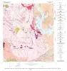
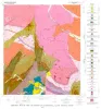
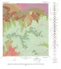
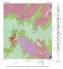
Geology of the Dunman Mountain Quadrangle, Llano, Burnet, and Blanco Counties, Texas | 1978 | Barnes, V.E. | Geologic Quadrangle Map | Bureau of Economic Geology | |
|
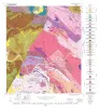
Geology of the Cap Mountain Quadrangle, Llano County, Texas | 1978 | Barnes, V.E. | Geologic Quadrangle Map | Bureau of Economic Geology | |
|
Geology of the Howell Mountain quadrangle, Blanco and Llano Counties, Texas | 1978 | Barnes, V.E. | Geologic Quadrangle Map | Bureau of Economic Geology | |
|
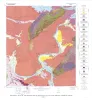
Geologic map of the Round Mountain quadrangle, Blanco, Burnet, and Llano counties. Texas | 1978 | Barnes, V.E. | Geologic Quadrangle Map | Bureau of Economic Geology | |
|
Geology of the Click Quadrangle, Llano and Blanco Counties, Texas | 1977 | Barnes, V.E. | Geologic Quadrangle Map | Bureau of Economic Geology | |
|
The Moore Hollow Group of central Texas | 1977 | Middle and Upper Cambrian rocks and locally up to 90 feet of Lower Ordovician rocks in Central Texas, are here named the Moore Hollow Group. |
Barnes, V.E., Bell, W.C. | Report of Investigations | |
|
Geology of the Kingsland Quadrangle, Llano and Burnet Counties, Texas | 1976 | Barnes, V.E. | Geologic Quadrangle Map | Bureau of Economic Geology | |
|
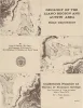
Geology of the Llano region and Austin area: field excursion | 1972 | This Guidebook represents an updating of Bureau of Economic Geology Guidebook No. 5, Field Excursion-Geology of Llano Region and Austin Area. It also represents a modification of Geology of the Llano Region and Austin Area, Texas, published by the Shreveport Geological Society in 1971. |
Barnes, V.E., Bell, W.C., Clabaugh, S.E., Cloud, P.E., Jr., McGehee, R.V., Rodda, P.U., Young, Keith | Guidebook | Bureau of Economic Geology |

|
Trilobites of the Upper Cambrian Ptychaspid biomere, Wilberns Formation, central Texas | 1970 | Trilobites collected during the past 20 years from the Morgan Creek, Point Peak, and San Saba Members of the Wilberns Formation comprise 89 species assigned to 45 genera belonging to zones of the upper Franconian and Trempealeauan Stages of the Upper Cambrian Croixan Series. |
Longacre, S.A. | Report of Investigations | Bureau of Economic Geology |