Publications in Hunt
| Title | Publication Year Sort ascending | Abstract | Author | Series | Publisher | |
|---|---|---|---|---|---|---|
|
Suitability of salt domes in the east Texas basin for nuclear waste isolation: final summary of geologic and hydrologic research (1978 to 1983) | 1984 | This report summarizes results of the East Texas Waste Isolation (ETWI) program from January 1, 1978, to March 30, 1983. Having an extensive data base, the study comprised 33 different lines of research by 67 scientists and research assistants. |
Jackson, M.P.A., Seni, S.J. | Geological Circular | Bureau of Economic Geology |
|
Cotton Valley (Upper Jurassic) and Hosston (Lower Cretaceous) depositional systems and their influence on salt tectonics in the east Texas basin | 1984 | Correct interpretation of the effect of basin infilling on salt mobilization is critical to understanding salt dome growth and stability. The size of salt structures in the East Texas Basin is determined by the original thickness of the underlying Louann Salt (Middle Jurassic). |
McGowen, M.K., Harris, D.W. | Geological Circular | Bureau of Economic Geology |
|
Sedimentary record of Cretaceous and Tertiary salt movement, east Texas basin: times, rates, and volumes of salt flow and their implications for nuclear waste isolation and petroleum exploration | 1984 | Post-Aptian strata (younger than 112 ma) in the East Texas Basin were strongly influenced by halokinesis and recorded the evolution associated sate structures. |
Seni, S.J., Jackson, M.P.A. | Report of Investigations | Bureau of Economic Geology |

|
Depositional systems in the Nacatoch Formation (Upper Cretaceous), northeast Texas and southwest Arkansas | 1983 | The Nacatoch Formation of the East Texas Basin is the middle formation of the Navarro Group and consists of marine sandstones and mudstones derived largely from source areas to the northwest, north, and northeast of the East Texas Embayment. |
McGowan, M.K., Lopez, C.M. | Report of Investigations | Bureau of Economic Geology |
|
Fault tectonics of the east Texas basin | 1982 | Principal fault systems in the East Texas Basin were examined in terms of their distribution, geometry, displacement history, and possible origins. |
Jackson, M.P.A., Wilson, B.D. | Geological Circular | Bureau of Economic Geology |
|
Hydrocarbon accumulation patterns in the east Texas salt dome province | 1982 | Mobilization of the Louann Salt created the present structural configuration in the central part of the East Texas Basin and was the major control on hydrocarbon accumulation in the area. Salt-cored anticlines, turtle-structure anticlines, and salt diapirs were produced by flow of salt. |
Wood, D.H., Giles, A.B. | Geological Circular | Bureau of Economic Geology |
|
Regional structural cross sections and general stratigraphy, east Texas basin | 1981 | Jurassic, Cretaceous, and Tertiary sediments in the East Texas Basin have been structurally modified by movement of Middle Jurassic Louann Salt. |
Wood, D.H., Guevara, E.H. | Cross Sections | Bureau of Economic Geology |
|
Geology and geohydrology of the east Texas basin -- a report on the progress of nuclear waste isolation feasibility studies (1980) | 1981 | The third year of research was highlighted by the integration of regional basinal studies with growth histories for specific domes, studies of cap-rock diagenesis and salt deformation, preliminary studies of ground-water flow and geochemistry around Oakwood Dome, and preliminary studies of micros |
Kreitler, C.W., Collins, E.W., Davidson, E.D., Dix, O.R., Donaldson, G.A., Dutton, S.P., Fogg, G.E., Giles, A.B. | Geological Circular | Bureau of Economic Geology |
|
Geologic Atlas of Texas, Dallas sheet (revised 1987) | 1972 | Geologic map that depicts surface geology of Tarrant, Dallas, Kaufman, Ellis, Johnson, Somervell, and Rockwall Counties and parts of Parker, Hood, Erath, Bosque, Hill, Navarro, Henderson, Van Zandt, and Hunt Counties, Texas. |
Barnes, V.E., Shell Oil Co., Humble Oil and Refining Co., Dallas Geological Society, Fort Worth Geological Society, McGowen, J.H., Proctor, C.V., Jr., Haenggi, W.T. | Geologic Atlas of Texas | Bureau of Economic Geology |
|
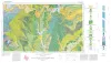
Geologic Atlas of Texas, Sherman sheet (revised 1991) | 1967 | Geologic map that depicts the surface geology of Montague, Cooke, Grayson, Wise, Denton, and Collin Counties and parts of Jack, Fannin, Hunt, and Clay Counties, Texas. The 16-page booklet indicates geologic formations, abbreviations, and ages. |
McGowen, J.H., Hentz, T.F., Owen, D.E., Pieper, M.K., Shelby, C.A., Barnes, V.E., Humble Oil and Refining Co., Pure Oil Co. | Geologic Atlas of Texas | Bureau of Economic Geology |