Publications in Hidalgo
| Title | Publication Year Sort ascending | Abstract | Author | Series | Publisher | |
|---|---|---|---|---|---|---|
|
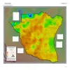
Geothermal Resources, South Texas | 2024 | A series of two 1:500,000 scale maps showing the Geothermal resources of South Texas. |
Andrews, J.R. | Open-File Map | Bureau of Economic Geology |
|
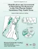
Identification and assessment of remaining oil resources in the Frio fluvial-deltaic sandstone play, south Texas | 1995 | The Frio Fluvial-Deltaic Sandstone (Vicksburg Fault Zone) play of South Texas has produced nearly 1 billion barrels (Bbbl) of oil since field development began in the 1940's. |
Holtz, M.H., McRae, L.E. | Report of Investigations | Bureau of Economic Geology |
|
Use of dipmeters in stratigraphic and depositional interpretation of natural gas reservoirs of the Oligocene Vicksburg Formation: an example from McAllen Ranch field, Hidalgo County, Texas | 1994 | Dipmeter analyses performed within McAllen Ranch field, Hidalgo County, South Texas, proved useful in finding reserves of natural gas. |
Langford, R.P., Hall, J.D., Howard, W.E. | Geological Circular | Bureau of Economic Geology |
|
Depositional Environments of Unstable Shelf-Margin Deltas of the Oligocene Vicksburg Formation, McAllen Ranch Field, South Texas | 1994 | Cores and supporting petrophysical data from 20 wells in McAllen Ranch field were analyzed. |
Langford, R.P., Combes, J.M. | Report of Investigations | Bureau of Economic Geology |

|
Reservoir heterogeneity and permeability barriers in the Vicksburg S Reservoir, McAllen Ranch gas field, Hidalgo County, Texas | 1994 | This report documents research done on the mature and prolific McAllen Ranch gas field in South Texas, as part of the Secondary Gas Recovery (SGR) project funded by the Gas Research Institute, U.S. |
Langford, R.P., Grigsby, J.D., Collins, R.E., Sippel, M.A., Wermund, E.G. | Report of Investigations | Bureau of Economic Geology |
|
Submerged lands of Texas, Brownsville - Harlingen area: sediments, geochemistry, benthic macroinvertebrates, and associated wetlands | 1986 | The State-owned submerged lands of Texas encompass almost 6,000 mi2 (15,540 km2). They lie below waters of the bay-estuary-lagoon system and the Gulf of Mexico and extend 10.3 mi (16.6 km) seaward from the Gulf shoreline (fig. 1). |
White, W.A., Calnan, T.R., Morton, R.A., Kimble, R.S., Littleton, T.G., McGowen, J.H., Nance, H.S., Schmedes, K.E. | Submerged Lands of Texas | Bureau of Economic Geology |

|
Structural cross sections, Tertiary formations, Texas Gulf Coast | 1981 | The publication comprises 24 structural dip cross sections, spaced 15 to 20 mi apart along the Texas coast, and 4 structural strike cross sections. Dip sections extend from near the Wilcox outcrop to the coastline. |
Dodge, M.M., Posey, J.S. | Cross Sections | Bureau of Economic Geology |
|
Environmental geologic Atlas of the Texas coastal zone -- Brownsville-Harlingen area | 1980 | The Texas Coastal Zone is marked by diversity in geography, resources, climate, and industry. |
Brown, L.F., Jr., Brewton, J.L., Evans, T.J., McGowen, J.H., White, W.A., Groat, C.G., Fisher, W.L. | Environmental Geologic Atlas of the Texas Coastal Zone | Bureau of Economic Geology |
|
Sandstone distribution and potential for geopressured geothermal energy production in the Vicksburg Formation along the Texas Gulf coast | 1979 | Potential geopressured geothermal reservoirs in the Vicksburg Formation are limited to Hidalgo County along the Lower Texas Gulf Coast. |
Loucks, R.G. | Geological Circular | Bureau of Economic Geology |
|
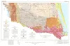
Geologic Atlas of Texas, McAllen-Brownsville sheet | 1976 | Geologic map that depicts surface geology of Starr, Hidalgo, Willacy, and Cameron Counties and parts of Zapata, Jim Hogg, Brooks, and Kenedy Counties. |
Barnes, V.E., Humble Oil and Refining Co., Shell Oil Co., Mobil Oil Co., Owens, Frith, Brewton, J.L., Aronow, Saul, Martin, R.G. | Geologic Atlas of Texas | Bureau of Economic Geology |