Publications in Gonzales
| Title | Publication Year Sort ascending | Abstract | Author | Series | Publisher | |
|---|---|---|---|---|---|---|
|
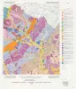
Geologic map of the Luling quadrangle, Texas | 1999 | Collins, E.W. | Open-File Map | Bureau of Economic Geology | |
|
The Guadalupe - Lavaca - San Antonio - Nueces River basins regional study: Seguin West - Austin West sheets | 1985 | Wermund, E.G., Gustavson, T.C., Morton, R.A., Woodruff, C.M., Jr., Macpherson, G.L., McKinney, L., Nilsson, J., Waddell, C.T. | River Basins Regional Studies | Bureau of Economic Geology | |
|
Depositional and diagenetic history of the Sligo and Hosston Formations(Lower Cretaceous) in south Texas | 1981 | The Sligo and Hosston Formations of Aptian age occur over thousands of square miles in the subsurface of South Texas. |
Bebout, D.G., Budd, D.A., Schatzinger, R.A. | Report of Investigations | Bureau of Economic Geology |

|
Structural cross sections, Tertiary formations, Texas Gulf Coast | 1981 | The publication comprises 24 structural dip cross sections, spaced 15 to 20 mi apart along the Texas coast, and 4 structural strike cross sections. Dip sections extend from near the Wilcox outcrop to the coastline. |
Dodge, M.M., Posey, J.S. | Cross Sections | Bureau of Economic Geology |
|
South Texas uranium province -- geologic perspective | 1979 | Galloway, W.E., Finley, R.J., Henry, C.D. | Guidebook | Bureau of Economic Geology | |
|
Catahoula Formation of the Texas coastal plain: depositional systems, composition, structural development, ground-water flow history, and uranium distribution | 1977 | The Catahoula Formation of the Texas Gulf Coastal Plain consists of two depositional systems--the Gueydan bedload fluvial system of the Rio Grande embayment and the Chita-Corrigan mixed load fluvial system of the Houston embayment. |
Galloway, W.E., Murphy, T.D., Belcher, R.C., Johnson, B.D., Sutton, Stanley | Report of Investigations | Bureau of Economic Geology |
|
South Texas uranium province: geology and extraction | 1976 | The increasing demand for uranium combined with the improving economics of uranium production have resulted in a significant upsurge in exploration and mining efforts in the South Texas Coastal Plain uranium province. Texas ranks third in U.S. uranium production. |
Galloway, W.E., Groat, C.G. | Research Note | |
|
Microrelief (Gilgai) Structures on Expansive Clays of the Texas Coastal Plain: Their Recognition and Significance in Engineering Construction | 1975 | Cracked pavements, undulating road surfaces, broken curbs, stairstep fractures of brick and stone building walls, and tilted power poles are common occurrences in areas underlain by cracking, expansive clay soils of the Vertisol order. |
Gustavson, T.C. | Geological Circular | Bureau of Economic Geology |
|
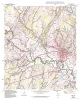
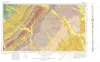
Geologic Atlas of Texas, Seguin sheet | 1974 | Geologic map that depicts the surface geology of Colorado, Lavaca, and Gonzales Counties, and parts of Hays, Caldwell, Bastrop, Fayette, Austin, Waller, Fort Bend, Wharton, Matagorda, Jackson, Victoria, De Witt, Karnes, Wilson, and Guadalupe Counties, Texas. |
Barnes, V.E., Humble Oil and Refining Co., Shell Oil Co., Mobil Oil Co., Proctor, C.V., Jr., Brown, T.E., Waechter, N.B., Aronow, Saul | Geologic Atlas of Texas | Bureau of Economic Geology |
|
Lithology and petrology of the Gueydan (Catahoula) Formation in south Texas | 1968 | Tuff, tuffaceous sand and clay, bentonite, and sandstone containing abundant volcanic rock detritus are present in Gulf Coast Tertiary rocks ranging in age from Eocene to Pliocene. |
McBride, E.F., Lindemann, W.L., Freeman, P.S. | Report of Investigations | Bureau of Economic Geology |