Publications in Fayette
| Title | Publication Year Sort ascending | Abstract | Author | Series | Publisher | |
|---|---|---|---|---|---|---|

|
Structural cross sections, Tertiary formations, Texas Gulf Coast | 1981 | The publication comprises 24 structural dip cross sections, spaced 15 to 20 mi apart along the Texas coast, and 4 structural strike cross sections. Dip sections extend from near the Wilcox outcrop to the coastline. |
Dodge, M.M., Posey, J.S. | Cross Sections | Bureau of Economic Geology |
|
Upper Tertiary and Quaternary depositional systems, central coastal plain, Texas -- regional geology of the coastal aquifer and potential liquid-waste repositories | 1981 | Upper Miocene, Pliocene, and Pleistocene deposits in the subsurface of the central Coastal Plain of Texas were subdivided into six operational units comprising the surface-defined Fleming, Goliad, Willis, Lissie, and Beaumont Formations. |
Solis-Iriarte, R.F. | Report of Investigations | Bureau of Economic Geology |
|
Land resource overview of the Capital Area Planning Council Region, Texas -- a nontechnical guide | 1979 | Bastrop, Blanco, Burnet, Caldwell, Fayette, Hays, Lee, Llano, Travis, and Williamson Counties make up the Capital Area Planning Council (CAPCO) region in Central Texas (fig. 1). The region covers 8,427 square miles (21,826 km2) and includes land of great physical diversity. |
Woodruff, C.M., Jr. | Selected Reports | Bureau of Economic Geology |
|
Proceedings, Gulf Coast Lignite Conference: Geology, Utilization, and Environmental Aspects | 1978 | Papers in this volume were presented at the Gulf Coast Lignite Conference held in Austin, Texas, June 1976. |
Kaiser, W.R., McNulty, J.E. | Report of Investigations | Bureau of Economic Geology |
|
Catahoula Formation of the Texas coastal plain: depositional systems, composition, structural development, ground-water flow history, and uranium distribution | 1977 | The Catahoula Formation of the Texas Gulf Coastal Plain consists of two depositional systems--the Gueydan bedload fluvial system of the Rio Grande embayment and the Chita-Corrigan mixed load fluvial system of the Houston embayment. |
Galloway, W.E., Murphy, T.D., Belcher, R.C., Johnson, B.D., Sutton, Stanley | Report of Investigations | Bureau of Economic Geology |
|
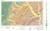
Geologic Atlas of Texas, Austin sheet | 1974 | Geologic map that depicts the surface geology of Burleson, Lee, Washington, and Brazos Counties and parts of Burnet, Bell, Milam, Robertson, Madison, Grimes, Waller, Austin, Fayette, Bastrop, Caldwell, Hays, Travis, and Williamson Counties. |
Barnes, V.E., Shell Oil Co., Humble Oil and Refining Co., Mobil Oil Co., Proctor, C.V., Jr., Brown, T.E., McGowen, J.H., Waechter, N.B. | Geologic Atlas of Texas | Bureau of Economic Geology |
|
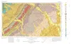
Geologic Atlas of Texas, Seguin sheet | 1974 | Geologic map that depicts the surface geology of Colorado, Lavaca, and Gonzales Counties, and parts of Hays, Caldwell, Bastrop, Fayette, Austin, Waller, Fort Bend, Wharton, Matagorda, Jackson, Victoria, De Witt, Karnes, Wilson, and Guadalupe Counties, Texas. |
Barnes, V.E., Humble Oil and Refining Co., Shell Oil Co., Mobil Oil Co., Proctor, C.V., Jr., Brown, T.E., Waechter, N.B., Aronow, Saul | Geologic Atlas of Texas | Bureau of Economic Geology |

|
Lithology and petrology of the Gueydan (Catahoula) Formation in south Texas | 1968 | Tuff, tuffaceous sand and clay, bentonite, and sandstone containing abundant volcanic rock detritus are present in Gulf Coast Tertiary rocks ranging in age from Eocene to Pliocene. |
McBride, E.F., Lindemann, W.L., Freeman, P.S. | Report of Investigations | Bureau of Economic Geology |

|
Lignites of the Texas Gulf coastal plain | 1963 | One of the basic mineral resources of Texas is abundant deposits of lignite in Eocene rocks of the Gulf Coastal Plain. |
Fisher, W.L. | Report of Investigations | Bureau of Economic Geology |
|
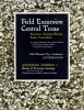
Field excursion central Texas -- bentonites, uranium-bearing rocks, vermiculites | 1961 | The departure point of the Villa Capri Motor Hotel may be gone, but the geologic information within Guidebook Number 3 remains relevant to this day: "The four stops of this field trip are in the Upper Eocene (Jackson) and Oligocene volcanic ash and bentonite beds, which crop out about |
Folk, R.L., Hayes, M.O., Brown, T.E., Eargle, D.H., Weeks, A.D., Barnes, V.E., Clabaugh, S.E. | Guidebook | Bureau of Economic Geology |