|
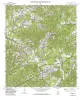
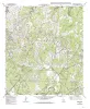
Geologic map of the Jack Mountain Quadrangle, Texas |
1995 |
|
Collins, E.W. |
Open-File Map |
Bureau of Economic Geology |
|
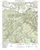
Geologic map of the Longhorn quadrangle, Texas |
1994 |
|
Collins, E.W. |
Open-File Map |
Bureau of Economic Geology |
|
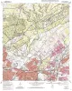
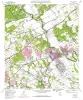
Geologic map of the Castle Hills quadrangle, Texas |
1994 |
|
Collins, E.W. |
Open-File Map |
Bureau of Economic Geology |
|
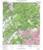
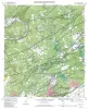
Geologic map of the Camp Bullis quadrangle, Texas |
1994 |
|
Collins, E.W. |
Open-File Map |
Bureau of Economic Geology |
|
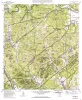
Geologic map of the Bergheim quadrangle, Texas |
1994 |
|
Collins, E.W. |
Open-File Map |
Bureau of Economic Geology |
|
Geologic map of the Schertz quadrangle, Texas |
1993 |
|
Collins, E.W. |
Open-File Map |
Bureau of Economic Geology |
|
Geologic map of the Bulverde quadrangle, Texas |
1993 |
|
Collins, E.W. |
Open-File Map |
Bureau of Economic Geology |
|
Geologic map of the Bat Cave quadrangle, Texas |
1993 |
|
Collins, E.W. |
Open-File Map |
Bureau of Economic Geology |
|
Geologic map of the Marion Quadrangle, Texas |
1993 |
|
Collins, E.W. |
Open-File Map |
Bureau of Economic Geology |
|
The Guadalupe - Lavaca - San Antonio - Nueces River basins regional study: San Antonio East - Llano East sheets |
1985 |
|
Wermund, E.G., Gustavson, T.C., Garner, L.E., Morton, R.A., Woodruff, C.M., Jr., Macpherson, G.L., McKinney, L., Nilsson, J. |
River Basins Regional Studies |
Bureau of Economic Geology |