Publication Search

Publications in Bexar

Title Publication Year Sort ascending Abstract Author Series Publisher
Geologic map of the Leming quadrangle, Texas Geologic map of the Leming quadrangle, Texas 2019 Elliott, Brent A. Open-File Map Bureau of Economic Geology
Geologic map of the Somerset quadrangle, Texas Geologic map of the Somerset quadrangle, Texas 2018 Elliott, Brent A. Open-File Map Bureau of Economic Geology
Geologic map of the Losoya quadrangle, Texas Geologic map of the Losoya quadrangle, Texas 2014 Elliott, Brent A. Open-File Map Bureau of Economic Geology
Geologic map of the Thelma quadrangle, Texas Geologic map of the Thelma quadrangle, Texas 2013 Elliott, Brent A. Open-File Map Bureau of Economic Geology
Permeability structure of the Edwards aquifer, south Texas -- implications for aquifer management Permeability structure of the Edwards aquifer, south Texas -- implications for aquifer management 1998

This report describes the three-dimensional distribution of hydraulic conductivity in the Edwards aquifer from Kinney to Comal Counties, Texas.

Hovorka, S.D., Mace, R.E., Collins, E.W. Report of Investigations Bureau of Economic Geology
Structure Map of the San Antonio Segment of the Edwards Aquifer and Balcones Fault Zone, South-Central Texas: Structural Framework of a Major Limestone Aquifer: Kinney, Uvalde, Medina, Bexar, Comal, and Hays Counties Structure Map of the San Antonio Segment of the Edwards Aquifer and Balcones Fault Zone, South-Central Texas: Structural Framework of a Major Limestone Aquifer: Kinney, Uvalde, Medina, Bexar, Comal, and Hays Counties 1997 Collins, E.W., Hovorka, S.D. Miscellaneous Map Bureau of Economic Geology
Edwards aquifer ground-water resources:  geologic controls on porosity development in platform carbonates, south Texas Edwards aquifer ground-water resources: geologic controls on porosity development in platform carbonates, south Texas 1996

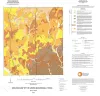
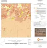
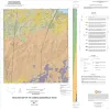
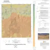
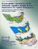
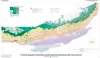
Focusing on the highly developed Edwards aquifer, which supplies water for a large area of south-central Texas, this report presents a three-dimensional model of the porosity distribution in the aquifer, which quantifies the spatial distribution of water resources and provides information that ca

Hovorka, S.D., Dutton, A.R., Ruppel, S.C., Yeh, J.S. Report of Investigations Bureau of Economic Geology
Geologic map of the San Geronimo Quadrangle, Texas Geologic map of the San Geronimo Quadrangle, Texas 1995 Collins, E.W. Open-File Map Bureau of Economic Geology
Geologic map of the Van Raub quadrangle, Texas Geologic map of the Van Raub quadrangle, Texas 1995 Collins, E.W. Open-File Map Bureau of Economic Geology
Geologic map of the Jack Mountain Quadrangle, Texas Geologic map of the Jack Mountain Quadrangle, Texas 1995 Collins, E.W. Open-File Map Bureau of Economic Geology