
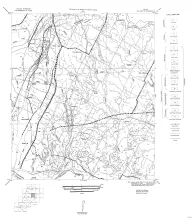
Fourteen black-and-white geologic maps prepared in 1957 and 1959 and obtained from the Department of Geological Sciences, University of Texas, and sold by the Bureau of Economic Geology. Geology compiled by F. L. Whitney; drafted by S. Espey, W. M. Strong, or W. L. Brooks; edited by K. P. Young.
Fourteen maps are included:
MM0016-A-Austin, NE (Travis and Williamson Counties)
MM0016-B-Austin, SW (Hays and Travis Counties)
MM0016-C-Bastrop (Travis County section)
MM0016-D-Blanco, SE (Hays County)
The eastern margin of the High Plains in central western Texas affords particularly good opportunity for study of late Cenozoic geology. The topography of the area is dominated by the southernmost segment of the late Tertiary mantle of fluvial sediments, isolated from the central and northern High Plains by the valley of the Canadian River. The eastern escarpment presents many exposures and the canyons that extend into the plains contain, in addition, a nearly complete sequence of Pleistocene terraces and deposits.