
This circular presents the history of "geological survey" in Texas from its beginning in 1858, through its intermittent early history, to [1965]. It also shows that any organization which carried the name "survey" was very short-lived in Texas. Whether this is because of early legislators’ convictions that a survey was something that was organized to do a specific job and then terminated, or whether there were deeper causes for the ephemeral nature of the early surveys is a matter for more thorough historical research and analysis.
This volume presents the texts of papers presented at a Symposium...sponsored by the Southwestern Federation of Geological Societies and The University of Texas in Austin, January 29, 1965. Publication was undertaken by the Bureau of Economic Geology in response to numerous requests for copies.
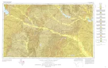
Stonewall quadrangle includes part of the southern margin of the Llano region and part of the eastern margin of the Edwards Plateau where most of the plateau suriace has been destroyed by erosion. An east-northeastward-trending lobe of the Edwards Plateau crosses the quadrangle near its southeastern corner. The area to the north is in the broad gently rolling Pedernales River basin, and that to the southeast is in a more rugged marginal part of the Blanco River drainage area. The geology of the Stonewall quadrangle is shown on a U.S.
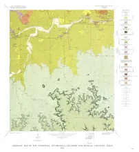
Geologic map that depicts the surface geology of Rains, Wood, Upshur, Marion, Harrison, Smith, and Gregg Counties and parts of Camp, Cass, Panola, Rusk, Cherokee, Anderson, Henderson, Van Zandt, Hunt, Morris, Franklin, and Hopkins Counties, Texas.
Studies along the southern and southeastern borders of the High Plains have demonstrated the presence of outliers of fossiliferous Ogallala Formation in Borden and Scurry counties and have documented the occurrence of Pliocene deposition as far southeast as Sterling County. The limit of characteristic Ash Hollow seed floras is extended to the southeast. An abandoned Pliocene and Pleistocene valley is described across a prong of Edwards Plateau south of Big Spring, and the drainage of the late Pleistocene Lake Lomax is determined to have occurred in pre-Bradyian Wisconsinan time.