
The Texas Coastal Zone is marked by diversity in geography, resources, climate, and industry. It is richly andowed with extensive petroleum reserves, sulfur and salt, deep-water ports, intracoastal waterways, mild climate, good water supplies, abundant wildlife, commercial fishing resources, unusual recreational potential, and large tracts of uncrowded land in close proximity to major population centers.
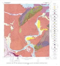
Geologic map that depicts the surface geology of Mills County and parts of Runnels, Coleman, Brown, Comanche, Erath, Hamilton, Coryell, Lampasas, San Saba, McCulloch, Concho, and Menard Counties. The 21-page booklet indicates geologic formations, abbreviations, and ages.
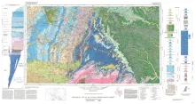
Geologic map that depicts the surface geology of parts of Webb, Duval, Jim Wells, Kleberg, Brooks, Jim Hogg, and Zapata Counties
Historical monitoring along Matagorda Peninsula from Brown Cedar Cut to Pass Cavallo records the nature and magnitude of changes in position of the shoreline and vegetation line and provides insight into the factors affecting those changes.