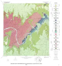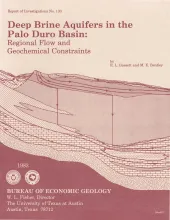
Geologic characterization of evaporite deposits as potential host rocks for burial of radioactive waste must include hydrogeologic investigations at both local and regional scales. The Palo Duro and Dalhart Basins of Texas contain candidate salt deposits that are underlain by shelf carbonates and fan-delta sandstones. These basins are ancient intracratonic elements exhibiting regional eastward flow in the deep brine aquifers.
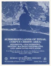
The State-owned submerged lands of Texas encompass almost 6,000 mi2 (15,540 km2). They lie below waters of the bay-estuary-lagoon system and the Gulf of Mexico and extend 10.3 mi (16.6 km) seaward from the Gulf shoreline (fig. 1). The importance of these lands and their resources to resident flora and fauna as well as to people is well known and documented; more than one-third of the state's population is concentrated within an area of the Coastal Zone that is only about one-sixteenth of the state's land area.
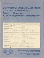
The top of mushroom-shaped Oakwood salt dome is approximately 210 m (700 ft) beneath the boundary of Freestone and Leon Counties near the southwestern end of the East Texas Basin, The dome is surrounded by Jurassic, Cretaceous, and lower Tertiary marine and nonrnarine strata. A salt pillow initially formed in Late Jurassic “Smackover” time, when faulting contributed to uneven sediment loading of the Louann Salt.
Official estimates of United States coal resources published during the past 15 years vary from less than 1.5 to 3.5 trillion metric tons (1.7 to 3.9 trillion short tons). These differences imply that a high degree of uncertainty exists in resource assessment. This report identifies sources of uncertainty in coal resource estimation. Our report focuses on the comparison of variability in coal resource estimates in areas of different ancient depositional environments.