
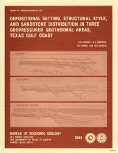
Three areas in the Texas Gulf Coastal Plain were studied using electric logs and seismic reflection data to interpret their depositional and structural history and to compare their potential as geopressured-geothermal reservoirs. The Cuero study area, on the lower Wilcox (upper Paleocene) growth-fault trend, is characterized by closely and evenly spaced, subparallel, down-to-the-basin growth faults, relatively small expansion ratios, and minor block rotation.
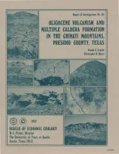
The Chinati Mountains caldera, which lies in Trans-Pecos Texas in the southern Basin and Range Province, was formed by eruption of the Mitchell Mesa Rhyolite. The caldera (30 km by 20 km) is part of a larger Oligocene volcanic province that includes Trans-Pecos Texas and extends to the Sierra Madre Occidental of western Mexico. Volcanism in the Chinati Mountains area began several million years before formation of the Chinati Mountains caldera. Rocks of the Morita Ranch Formation, Infiernito caldera, and Shely Group ring the caldera on the south, east, and north.
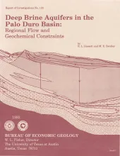
Geologic characterization of evaporite deposits as potential host rocks for burial of radioactive waste must include hydrogeologic investigations at both local and regional scales. The Palo Duro and Dalhart Basins of Texas contain candidate salt deposits that are underlain by shelf carbonates and fan-delta sandstones. These basins are ancient intracratonic elements exhibiting regional eastward flow in the deep brine aquifers.
The State-owned submerged lands of Texas encompass almost 6,000 mi2 (15,540 km2). They lie below waters of the bay-estuary-lagoon system and the Gulf of Mexico and extend 10.3 mi (16.6 km) seaward from the Gulf shoreline (fig. 1). The importance of these lands and their resources to resident flora and fauna as well as to people is well known and documented; more than one-third of the state's population is concentrated within an area of the Coastal Zone that is only about one-sixteenth of the state's land area.