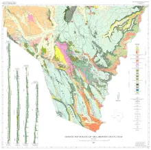
The wedge-shaped Black Gap area in southern Brewsier County, Texas, occupies approximately 4,50 square miles east of the Big Bend National Park. The southwestern boundary of the map area is the castcrn boundary of the Park; the southeastern boundary is the Rio Grande; the north boundary is drawn at lat. 29' 45' N. The area lies in the Trans-Pecos proxince and throughout this arid to semiarid region the climate, flora, and fauna are similar.
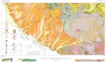
This report treats the sedimentary petrology and history of the Haymond Formation, a monotonous sequence of interbedded sandstone and shale that has a maximum preserved thickness of 4,300 feet. The upper part of the formation includes massive coarse sandstone beds and a complex of pebbly mudstones and slumped beds that encase exotic and erratic rock fragments up to 130 feet long. The Haymond is part of a 12,000-foot sequence of flysch that was deposited during late Paleozoic time in the Marathon geosyncline, a part of the Ouachita geosyncline located in Trans-Pecos Texas.
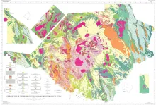
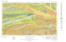
Geologic map that depicts the surface geology of Lamar, Red River, Bowie, Delta, and Titus Counties and parts of Fannin, Hunt, Camp, Cass, Hopkins, Franklin, and Morris Counties, Texas. The 6-page booklet indicates geologic formations, abbreviations, and ages.