The State of Texas has about 367 miles of open Gulf shoreline, most of it typified by rather broad, sandy beaches and a comparatively mild climate that permits almost year-round use of this recreational resource. All but about 87 miles of the Gulf beach is accessible to the general public.
The Texas Coastal Zone is marked by diversity in geography, resources, climate, and industry. It is richly andowed with extensive petroleum reserves, sulfur and salt, deep-water ports, intracoastal waterways, mild climate, good water supplies, abundant wildlife, commercial fishing resources, unusual recreational potential, and large tracts of uncrowded land in close proximity to major population centers.
Sequential shoreline monitoring, using vintage chans and aerial photographs, documents temporal and spatial variations in historical Gulf shoreline changes. The regional distribution of shoreline erosion and accretion largely reflects changes in littoral drift cells, decreases in sediment supply, and continuing relative sea-level rise including compactional subsidence. A Late Quaternary (circa 3500 BP) shoreline is postulated with promontories at the Holocene Brazos.
Three principal depositional systems were defined within the Sparta Formation of Texas using surface and subsurface data: high-constructive delta system in east Texas; strandplain-barrier bar system in central Texas; and high-destructive, wave-dominated delta system in south Texas.
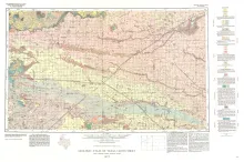
Geologic map that depicts the surface geology of Parmer and Castro Counties and parts of Deaf Smith, Randall, Bailey, Lamb, and Hale Counties.