Environmental Geology Publications
| Title | Publication Year Sort ascending | Abstract | Author | Series | Publisher | |
|---|---|---|---|---|---|---|
|
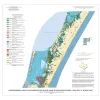
Geo-Environmental map of Southern Mustang Island, Crane Islands NW quadrangle, Texas Gulf of Mexico Coast | 2006 | Tremblay, T.A., Gibeaut, J.C., Waldinger, R.L., White, W.A., Collins, E.W. | Open-File Map | Bureau of Economic Geology | |
|
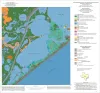
Geoenvironmental map of the Christmas Point quadrangle, Texas | 2004 | Tremblay, T.A., White, W.A., Waldinger, R.L., Collins, E.W. | Open-File Map | Bureau of Economic Geology | |
|
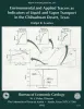
Environmental and applied tracers as indicators of liquid and vapor transport in the Chihuahuan Desert, Texas | 1992 | Chemical and physical approaches are used to study unsaturated flow; however, few studies include an in-depth analysis of data from both approaches. |
Scanlon, B.R. | Report of Investigations | Bureau of Economic Geology |
|
Environmental geology of the Yegua - Jackson lignite belt, southeast Texas | 1982 | Environmental geologic maps of the Texas lignite belt were prepared in response to renewed production of lignite in Texas and enactment of Federal and State laws governing coal and lignite surface mining. |
Jackson, M.L.W., Garner, L.E., Sharpe, R.D. | Report of Investigations | Bureau of Economic Geology |
|
Environmental geologic Atlas of the Texas coastal zone -- Brownsville-Harlingen area | 1980 | The Texas Coastal Zone is marked by diversity in geography, resources, climate, and industry. |
Brown, L.F., Jr., Brewton, J.L., Evans, T.J., McGowen, J.H., White, W.A., Groat, C.G., Fisher, W.L. | Environmental Geologic Atlas of the Texas Coastal Zone | Bureau of Economic Geology |

|
Environmental geology of the Wilcox Group lignite belt, east Texas | 1979 | This report provides a data base for decisions about lignite mining and reclamation in the Wilcox Group of East Texas. Kaiser (1974, 1978) estimates that about 12.2 billion short tons of potentially strip-minable lignite resources occur in East and South Texas. |
Henry, C.E., Basciano, J.M. | Report of Investigations | Bureau of Economic Geology |
|
Evaluating the Environmental Geology Map, Environmental Geologic Atlas of the Texas Coastal Zone | 1978 | Comparison of Environmental Geology maps, from the Environmental Geologic Atlas of the Texas Coastal Zone, with aerial photographs taken in February 1975 revealed changes related to economic development of the region and to ongoing natural processes. |
Finley, R.J. | Research Note | |
|
|
Evaluating the Environmental Geology Map, Environmental Geologic Atlas of the Texas Coastal Zone | 1978 | Comparison of Environmental Geology maps, from the Environmental Geologic Atlas of the Texas Coastal Zone, with aerial photographs taken in February 1975 revealed changes related to economic development of the region and to ongoing natural processes. |
Finley, R.J. | Research Note | |
|
Environmental geologic Atlas of the Texas coastal zone -- Kingsville area | 1977 | The Texas Coastal Zone is marked by diversity in geography, resources, climate, and industry. |
Brown, L.F., Jr., McGowen, J.H., Evans, T.J., Groat, C.G., Fisher, W.L. | Environmental Geologic Atlas of the Texas Coastal Zone | Bureau of Economic Geology |
|
Environmental geologic Atlas of the Texas coastal zone -- Port Lavaca area | 1976 | The Texas Coastal Zone is marked by diversity in geography, resources, climate, and industry. |
McGowen, J.H., Proctor, C.V., Jr., Brown, L.F., Jr., Evans, T.J., Fisher, W.L., Groat, C.G. | Environmental Geologic Atlas of the Texas Coastal Zone | Bureau of Economic Geology |