Geologic Maps Publications
| Title | Publication Year Sort ascending | Abstract | Author | Series | Publisher | |
|---|---|---|---|---|---|---|
|
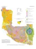
Down to earth at Big Bend Ranch State Park, Texas: geologic map and trail-side geology | 2002 | This full-color, oversize map, designed for hikers in the park, describes geologic units and features. The text documents the geologic history of the Big Bend Ranch State Park area. Support was provided by the Texas Parks and Wildlife Department and the U.S. Geological Survey. |
Henry, C.D., Raney, J.A. | Down To Earth | Bureau of Economic Geology |
|
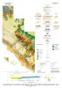
Geologic map of the central Hueco Bolson, Acala - Fort Hancock - Esperanza region, Texas | 2002 | Collins, E.W., Raney, J.A. | Miscellaneous Map | Bureau of Economic Geology | |
|
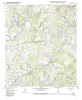
Geologic map of the Payton quadrangle, Texas | 2002 | Collins, E.W. | Open-File Map | Bureau of Economic Geology | |
|
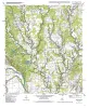
Geologic map of the Winchester quadrangle, Texas | 2001 | Collins, E.W. | Open-File Map | Bureau of Economic Geology | |
|
Geologic map of the Paige quadrangle, Texas | 2001 | Collins, E.W. | Open-File Map | Bureau of Economic Geology | |
|
Geologic map of the Concan quadrangle, Texas | 2001 | Collins, E.W. | Open-File Map | Bureau of Economic Geology | |
|
Geologic map of the Smithville Quadrangle, Texas | 2001 | Collins, E.W. | Open-File Map | Bureau of Economic Geology | |
|
Geologic map of the Smithville NW Quadrangle, Texas | 2001 | Collins, E.W. | Open-File Map | Bureau of Economic Geology | |
|
Geologic map of the Beaukiss quadrangle, Texas | 2001 | Collins, E.W. | Open-File Map | Bureau of Economic Geology | |
|
Geologic map of the Circle Bluff quadrangle, Texas | 2001 | Collins, E.W. | Open-File Map | Bureau of Economic Geology |