|
The Mineral Industry of Texas in 1966 |
Netzeband, F.F., Girard, R.M. |
1967 |
Mineral Resource Circular |
|
Lower Cretaceous sands of Texas: stratigraphy and resources |
Fisher, W.L., Rodda, P.U. |
1967 |
Report of Investigations |
|
Sand resources of Texas gulf coast |
Garner, L.E. |
1967 |
Report of Investigations |
|
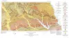
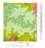
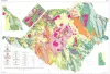
Geologic Atlas of Texas, Palestine sheet (revised 1993) |
Barnes, V.E., Humble Oil and Refining Co., Shell Oil Co., Pan American Petroleum Corp., Mobil Oil Co., Wright, A.C., McCallum, H.D., Wendlandt, E.A., Burford, S.O., Shelby, T.H., Gibson, D.T., Eaton, R.W., Shelby, C.A., Pieper, M.K. |
1967 |
Geologic Atlas of Texas |
|
Geology of the Cave Creek School Quadrangle, Gillespie County, Texas |
Barnes, V.E. |
1967 |
Geologic Quadrangle Map |
|
Late Cambrian and Early Ordovician faunas from the Wilberns Formation of central Texas |
Winston, Don, Nicholls, Harry |
1967 |
Report of Investigations |
|
GCAGS Transactions Volume 17 (1967) San Antonio |
|
1967 |
Gulf Coast Association of Geological Societies |
|
Annual Report of the Bureau of Economic Geology 1967 |
University of Texas at Austin, Bureau of Economic Geology |
1967 |
Annual Reports |
|
Geology of the Monument Hill Quadrangle, Blanco County, Texas |
Barnes, V.E. |
1967 |
Geologic Quadrangle Map |
|
Toward a Statistical Overview of the Archaic Cultures of Central and Southwestern Texas |
|
1967 |
Texas Memorial Museum |
|
Geology of the Yeager Creek Quadrangle, Blanco and Hays Counties, Texas |
Barnes, V.E. |
1967 |
Geologic Quadrangle Map |
|
Typical Oil & Gas Fields of South Texas, Vol. I |
|
1967 |
Corpus Christi Geological Society |
|
Geographic Variations in Survival of Hybrids between Etheostomatine Fishes |
|
1967 |
Texas Memorial Museum |
|
Mammalian Remains from Rattlesnake Cave, Kinney County, Texas |
|
1967 |
Texas Memorial Museum |
|
The Onion Creek Mosasaur |
|
1966 |
Texas Memorial Museum |
|
Geologic Atlas of Texas, Texarkana sheet (reprinted 1979 with base revised) |
Barnes, V.E., Humble Oil and Refining Co., Shell Oil Co., Pan American Petroleum Corp., Arkansas Geological and Conservation Commission, Oklahoma Geological Survey, McCallum, H.D., Wendlandt, E.A., Burford, S.O., Gibson, D.T., Eaton, R.W. |
1966 |
Geologic Atlas of Texas |
|
Geologic map of the Big Bend National Park, Brewster County, Texas |
Maxwell, R.A. |
1966 |
Miscellaneous Map |

|
Deltas in Their Geologic Framework |
|
1966 |
Houston Geological Society |
|
Limestone and dolomite resources, Lower Cretaceous rocks, Texas |
Rodda, P.U., Fisher, W.L., Payne, W.R., Schofield, D.A. |
1966 |
Report of Investigations |
|
Sedimentary petrology and history of the Haymond Formation (Pennsylvanian), Marathon Basin, Texas |
McBride, E.F. |
1966 |
Report of Investigations |