|
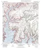
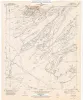
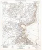
Geologic map of the Rough Canyon Quadrangle, Texas |
Collins, E.W. |
1997 |
Open-File Map |
|
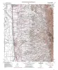
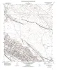
Geologic map of the Canutillo quadrangle, Texas |
Collins, E.W. |
1996 |
Open-File Map |
|
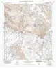
Geologic map of the Padre Canyon quadrangle, Texas |
Collins, E.W. |
1996 |
Open-File Map |

|
Combining P-Wave and S-Wave Seismic Data to Improve Prospect Evaluation |
Hardage, B.A. |
1996 |
Report of Investigations |
|
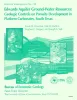
Edwards aquifer ground-water resources: geologic controls on porosity development in platform carbonates, south Texas |
Hovorka, S.D., Dutton, A.R., Ruppel, S.C., Yeh, J.S. |
1996 |
Report of Investigations |
|
GCAGS Transactions Volume 46 (1996) San Antonio |
|
1996 |
Gulf Coast Association of Geological Societies |
|
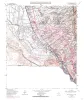
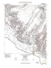
Geologic map of the Smeltertown quadrangle, Texas |
Collins, E.W. |
1996 |
Open-File Map |
|
Fluvial and eolian depositional systems, paleosols, and paleoclimate of the Upper Cenozoic Ogallala and Blackwater Draw Formations, southern High Plains, Texas and New Mexico |
Gustavson, T.C. |
1996 |
Report of Investigations |
|
Annual Report of the Bureau of Economic Geology 1996 |
University of Texas at Austin, Bureau of Economic Geology |
1996 |
Annual Reports |
|
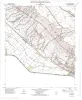
Geologic map of the Tornillo quadrangle, Texas |
Collins, E.W. |
1996 |
Open-File Map |
|
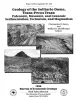
Geology of the Solitario dome, Trans-Pecos Texas: Paleozoic, Mesozoic, and Cenozoic sedimentation, tectonism, and magmatism |
Henry, C.D., Muehlberger, W.R., McCormick, C.L., Smith, C.I., Erdlac, R.J., Davis, L.L., Kunk, M.J. |
1996 |
Report of Investigations |
|
Geologic map of the Esperanza quadrangle, Texas |
Collins, E.W. |
1996 |
Open-File Map |
|
Geologic map of the T P Well quadrangle, Texas |
Collins, E.W. |
1996 |
Open-File Map |
|
Geologic map of the Whiterock Hills Quadrangle, Texas |
Collins, E.W. |
1996 |
Open-File Map |
|
Geologic map of the Fort Hancock NW quadrangle, Texas |
Collins, E.W. |
1996 |
Open-File Map |
|
Boonsville 3-D Seismic Data Set |
Hardage, B.A., Simmons, J.L., Jr., Lancaster, D.E., Elphick, R.Y., Edson, R.D., Carr, D.L., Pendleton, V.M. |
1996 |
Seminars and Workshops |
|
Lower Cenozoic Chronology of Gulf Chart, 1996. Two sheets in color with explanatory text on back of Sheet One |
|
1996 |
Gulf Coast Section SEPM |
|
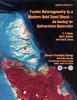
Facies Heterogeneity in a Modern Ooid Sand Shoal--An Analog for Hydrocarbon Reservoirs |
Major, R.P., Bebout, D.G., Harris, P.M. |
1996 |
Geological Circular |
|
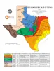
Physiographic Map of Texas |
Wermund, E.G. |
1996 |
Thematic Maps |
|
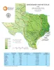
River Basin Map of Texas |
Wermund, E.G. |
1996 |
Thematic Maps |