|
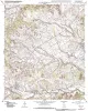
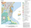
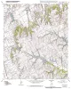
Geologic map of the Morgan quadrangle, Texas |
Collins, E.W. |
2009 |
Open-File Map |
|
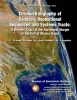
Annual Report of the Bureau of Economic Geology 2009 |
University of Texas at Austin, Bureau of Economic Geology |
2009 |
Annual Reports |
|
Supplement to Guidebook 14 |
Brown, L.F., Jr., Ambrose, W.A., Carr, D.L. |
2009 |
Guidebook |
|
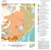
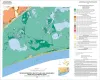
Geoenvironmental map of Big Hill Bayou quadrangle, Texas, Gulf of Mexico Coast |
Tremblay, T.A., Caudle, T.L., White, W.A. |
2009 |
Open-File Map |
|
Geoenvironmental map of Port Arthur South quadrangle, Texas, Gulf of Mexico Coast |
Tremblay, T.A., Caudle, T.L., White, W.A. |
2009 |
Open-File Map |
|
Geoenvironmental map of Clam Lake quadrangle, Texas, Gulf of Mexico Coast |
Tremblay, T.A., White, W.A., Caudle, T.L. |
2009 |
Open-File Map |
|
Geoenvironmental map of Sabine Pass and Texas Point quadrangles, Texas, Gulf of Mexico Coast |
Tremblay, T.A., White, W.A., Caudle, T.L. |
2009 |
Open-File Map |
|
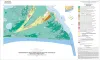
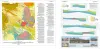
Chronostratigraphy of Cenozoic Depositional Sequences and Systems Tracts: A Wheeler Chart of the Northwest Margin of the Gulf of Mexico Basin |
Brown, L.F., Jr., Loucks, R.G. |
2009 |
Report of Investigations |
|
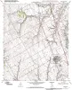
Geologic map of the Blum quadrangle, Texas |
Collins, E.W. |
2009 |
Open-File Map |
|
Geologic Map of the Covington quadrangle, Texas |
Collins, E.W. |
2009 |
Open-File Map |
|
Submarine Mass Movements and Their Consequences. 4th International Symposium |
Mosher, D.C., Shipp, R.C., Moscardelli, Lorena, Chaytor, J.D., Baxter, C.D.P., Lee, H.J., Urgeles, Roger |
2009 |
Selected Reports |
|
Earth's Art, Celebrating the Centennial of the Bureau of Economic Geology 1909-2009 |
Laubach, S.E., Tinker, S.W. |
2009 |
Udden Series |
|
Geologic Map of the Files Valley quadrangle, Texas |
Collins, E.W. |
2009 |
Open-File Map |
|
Geologic map of the Itasca quadrangle, Texas |
Collins, E.W. |
2009 |
Open-File Map |
|
Geologic map of the Glenn Spring quadrangle, Big Bend National Park, Texas |
Collins, E.W., Muehlberger, W.R., Dickerson, P.W. |
2008 |
Miscellaneous Map |
|
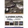
Landscapes, Water, and Man |
|
2008 |
South Texas Geological Society |
|
Geologic map of the Southeast Part of the Austin, Texas, 30x60 Minute Quadrangle; Central Texas Population Corridor Encompassing Bastrop and Smithville |
Collins, E.W. |
2008 |
Miscellaneous Map |
|
Sequence Stratigraphy and Depositional Systems of the Woodbine Group in East Texas Field: Core Workshop |
Ambrose, W.A., Hentz, T.F., Loucks, R.G., Clift, S.J., Potter, E.C., Bonnaffé, F. |
2008 |
Seminars and Workshops |
|
Canyon Dam Spillway Gorge, Comal County, Texas - Geologic and Hydrologic Issues |
Ward, William C., Molineux, Ann, Valentine, Shane, Woodruff, C.M., Jr. |
2008 |
Austin Geological Society |
|
GCAGS Transactions Volume 58 (2008) Houston |
|
2008 |
Gulf Coast Association of Geological Societies |