Publication Details
Geolocation:
Get the Publication
$11.50
Abstract/Description:
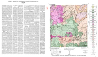
North Grape Creek quadrangle is south of the Llano region and is mostly in the broad Pedernales River basin. A few outliers of the Edwards Plateau are present in the western part of the quadrangle.
The geology of the North Grape Creek quadrangle is shown on a planimetric map, and the only topographic map available is the reconnaissance 30-minute Fredericksburg quadrangle. Elevations ranging between 1,294 and 1,775 feet were determined during traversing for control, but neither the highest nor the lowest elevation was reached. However, it is estimated that the relief within the quadrangle is about 640 feet, ranging between about 1,200 and 1,840 feet in elevation.
The quadrangle is entirely within the Pedernales River drainage basin and is mostly drained by North Grape Creek and its tributaries, some of which are White Oak Creek, Basin Spring Hollow, Dry Hollow, and Smith Spring Branch. The southern part of the quadrangle is drained by Pedernales River and its branches, some of which are Iron Rock Creek and Rocky Creek.
North Grape Creek quadrangle is high on the southeastern side of the Llano uplift, and rocks from pre-Cambrian to Ordovician in age outcrop in about three-quarters of the quadrangle. Faults related to the Ouachita orogeny trend mostly northeast-southwest; some trend east-west. The Cretaceous rocks are essentially horizontal, dipping eastward perhaps about 10 feet per mile.
Broader discussions of the stratigraphic, structural, economic, and geophysical problems of the region cannot be given in the space available. References cited below deal with some of the problems. This publication on the North Grape Creek quadrangle is one of a series of similar publications, an index to which is shown on the opposite page. The reader is referred to this index map to locate other quadrangles mentioned in the present text.