Publications in Zavala
| Title | Publication Year Sort ascending | Abstract | Author | Series | Publisher | |
|---|---|---|---|---|---|---|
|
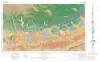
Geologic Atlas of Texas, San Antonio sheet (revised 1982) | 1974 | Geologic map that depicts the surface geology of Comal, Bandera, Bexar, and Medina Counties and parts of Real, Kerr, Kendall, Hays, Guadalupe, Wilson, Atascosa, Frio, Zavala, and Uvalde Counties, Texas. The 9-page booklet indicates geologic formations, abbreviations, and ages. |
Barnes, V.E., Shell Oil Co., Amerada Petroleum Corp., Brown, T.E., Waechter, N.B., Dillon, R.L. | Geologic Atlas of Texas | Bureau of Economic Geology |

|
Mineral resources of south Texas: region served through the port of Corpus Christi | 1962 | This report is a compilation of all available data on mineral resources (exclusive of oil and gas) in 39 south Texas counties. Information from published and unpublished sources was checked and supplemented by field investigations. |
Maxwell, R.A. | Report of Investigations | Bureau of Economic Geology |
|
Mineral Resources of Uvalde, Zavala, and Maverick Counties Texas | 1931 | Uvalde County is located in southwestern Texas, including part of the north margin of the Gulf Coastal Plain and the south margin of the Edwards Plateau. Its principal mineral resources are asphalt rock, clay, limestone, gravel, trap rock, and surface and underground water. |
Getzendaner, F.M. | Mineral Resource Pamphlet | |
|
Well Records of Zavala County Texas | 1928 | These circulars issued from the Bureau of Economic Geology contain the record of cores and cuttings from well received and described in the Bureau. |
Well Record | ||
|
Igneous rocks of the Balcones fault region of Texas | 1927 | Lonsdale, J.T. | UT Bulletin |