Publications in Zapata
| Title | Publication Year Sort ascending | Abstract | Author | Series | Publisher | |
|---|---|---|---|---|---|---|
|
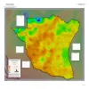
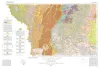
Geothermal Resources, South Texas | 2024 | A series of two 1:500,000 scale maps showing the Geothermal resources of South Texas. |
Andrews, J.R. | Open-File Map | Bureau of Economic Geology |
|
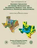
Pavement Deflection and Seismic Refraction for Determining Bedrock Type, Depth, and Physical Properties beneath Roads | 2000 | We examined the relationship between three data types--geologic maps, measurements of pavement deflection under load, and seismic refraction data-- from diverse geologic settings in Texas to determine (1) whether geologic maps and seismic refraction data might be used to interpret deflections and |
Paine, J.G., Murphy, M.R. | Report of Investigations | Bureau of Economic Geology |
|
Increased Oil Recovery Potential from Barrier/Strandplain Reservoirs, Jackson-Yegua Trend, by Geologically Targeted Infill Drilling: Examples from Seventy-Six West and Colmena-Cedro Hill Fields, South Texas | 1994 | The Jackson-Yegua Barrier/Strandplain Sandstone play is a prolific oil-producing trend in South Texas that has high average porosity (31 percent) and permeability (600 md). |
Hamilton, D.S. | Report of Investigations | Bureau of Economic Geology |

|
Structural cross sections, Tertiary formations, Texas Gulf Coast | 1981 | The publication comprises 24 structural dip cross sections, spaced 15 to 20 mi apart along the Texas coast, and 4 structural strike cross sections. Dip sections extend from near the Wilcox outcrop to the coastline. |
Dodge, M.M., Posey, J.S. | Cross Sections | Bureau of Economic Geology |
|
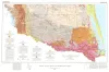
Geologic Atlas of Texas, McAllen-Brownsville sheet | 1976 | Geologic map that depicts surface geology of Starr, Hidalgo, Willacy, and Cameron Counties and parts of Zapata, Jim Hogg, Brooks, and Kenedy Counties. |
Barnes, V.E., Humble Oil and Refining Co., Shell Oil Co., Mobil Oil Co., Owens, Frith, Brewton, J.L., Aronow, Saul, Martin, R.G. | Geologic Atlas of Texas | Bureau of Economic Geology |
|
Geologic Atlas of Texas, Laredo sheet | 1976 | Geologic map that depicts the surface geology of parts of Webb, Duval, Jim Wells, Kleberg, Brooks, Jim Hogg, and Zapata Counties |
Barnes, V.E., Mobil Oil Co., Shell Oil Co., Humble Oil and Refining Co., Owens, Frith, Brewton, J.L., Tobin, Edward, Martin, R.G. | Geologic Atlas of Texas | Bureau of Economic Geology |
|
Geothermal resources, Frio Formation, South Texas | 1974 | A preliminary study of the Frio sand distribution and formation temperatures and pressures was undertaken in order to define prospective areas in which a more detailed reservoir analysis is necessary prior to the selection of a site for a geothermal well. |
Bebout, D.G., Dorfman, M.H., Agagu, O.K., Granata, G.E., Sanders, G.B. | Geological Circular | Bureau of Economic Geology |
|
Lithology and petrology of the Gueydan (Catahoula) Formation in south Texas | 1968 | Tuff, tuffaceous sand and clay, bentonite, and sandstone containing abundant volcanic rock detritus are present in Gulf Coast Tertiary rocks ranging in age from Eocene to Pliocene. |
McBride, E.F., Lindemann, W.L., Freeman, P.S. | Report of Investigations | Bureau of Economic Geology |
|
The Gueydan, a new Middle Tertiary formation from the southwestern coastal plain of Texas | 1926 | Bailey, T.L. | UT Bulletin | ||
|
Notes on the oil and gas fields of Webb and Zapata Counties -- The underground position of the Austin Formation in the San Antonio oil fields | 1922 | Sellards, E.H. | UT Bulletin |