Publications in Val Verde
Title | Publication Year | Abstract | Author | Series | Publisher | |
---|---|---|---|---|---|---|
![]() |
Regional stratigraphic cross sections, Comanche Cretaceous (Fredericksburg - Washita Division), Edwards and Stockton plateaus, West Texas: interpretation of sedimentary facies, depositional cycles, and tectonics | 2000 | 
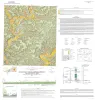
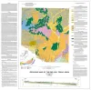
Six interlocking regional stratigraphic cross sections of Lower Cretaceous strata (middle Albian-lower Cenomanian) of the Edwards and Stockton Plateaus of West Texas illustrate the vertical and lateral extent of lithostratigraphic units and distribution of facies and facies tracts. |
Smith, C.I., Brown, J.B., Lozo, F.E. | Cross Sections | Bureau of Economic Geology |
![]() |
Geologic Atlas of Texas, Del Rio sheet | 1977 | Geologic map that depicts surface geology of Kinney County and parts of Terrell, Val Verde, Edwards, Real, Uvalde, and Maverick Counties, Texas. |
Barnes, V.E., Waechter, N.B., Pinkley, G.R., Martin, R.G., Wyeth, J.C., Knupke, J.A., Sulik, J.F., Ellis, W.G. | Geologic Atlas of Texas | Bureau of Economic Geology |
![]() |
Geologic Atlas of Texas, Sonora sheet | 1981 | Geologic map that depicts the surface geology of Sutton County and parts of Terrell, Crockett, Val Verde, Edwards, Kimble, Menard, Schleicher, and Pecos Counties. |
Barnes, V.E., McKalips, D.G., Cities Service Petroleum Co., Geophoto Services Inc., Stump, R.W., Brown, J.B., Pearson, B.T., Volkmann, R.G. | Geologic Atlas of Texas | Bureau of Economic Geology |
![]() |
Electrical Imaging Catalog: Microresistivity Images and Core Photos from Fractured, Karsted, and Brecciated Carbonates | 1997 | Electrical images in boreholes are becoming increasingly important in interpreting the rock record. |
Hammes, Ursula | Geological Circular | Bureau of Economic Geology |
![]() |
Geology of the Carta Valley fault zone area: Edwards, Kinney, and Val Verde Counties, Texas | 1982 | Webster, R.E. | Geologic Quadrangle Map | Bureau of Economic Geology | |
![]() |
Geologic map of the Del Rio, Texas, area | 2007 | Collins, E.W. | Miscellaneous Map | Bureau of Economic Geology | |
![]() |
Geologic map of the Del Rio NW Quadrangle, Texas | 1997 | Collins, E.W. | Open-File Map | Bureau of Economic Geology | |
![]() |
Geologic map of the Del Rio SW Quadrangle, Texas | 1997 | Collins, E.W. | Open-File Map | Bureau of Economic Geology | |
![]() |
Geologic map of the Rough Canyon SE Quadrangle, Texas | 1998 | Collins, E.W. | Open-File Map | Bureau of Economic Geology | |
![]() |
Geologic map of the Del Rio NE Quadrangle, Texas | 1998 | Collins, E.W. | Open-File Map | Bureau of Economic Geology |