Publications in Starr
| Title | Publication Year Sort ascending | Abstract | Author | Series | Publisher | |
|---|---|---|---|---|---|---|
|
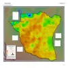
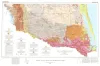
Geothermal Resources, South Texas | 2024 | A series of two 1:500,000 scale maps showing the Geothermal resources of South Texas. |
Andrews, J.R. | Open-File Map | Bureau of Economic Geology |
|
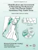
Identification and assessment of remaining oil resources in the Frio fluvial-deltaic sandstone play, south Texas | 1995 | The Frio Fluvial-Deltaic Sandstone (Vicksburg Fault Zone) play of South Texas has produced nearly 1 billion barrels (Bbbl) of oil since field development began in the 1940's. |
Holtz, M.H., McRae, L.E. | Report of Investigations | Bureau of Economic Geology |
|
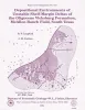
Depositional Environments of Unstable Shelf-Margin Deltas of the Oligocene Vicksburg Formation, McAllen Ranch Field, South Texas | 1994 | Cores and supporting petrophysical data from 20 wells in McAllen Ranch field were analyzed. |
Langford, R.P., Combes, J.M. | Report of Investigations | Bureau of Economic Geology |

|
Structural cross sections, Tertiary formations, Texas Gulf Coast | 1981 | The publication comprises 24 structural dip cross sections, spaced 15 to 20 mi apart along the Texas coast, and 4 structural strike cross sections. Dip sections extend from near the Wilcox outcrop to the coastline. |
Dodge, M.M., Posey, J.S. | Cross Sections | Bureau of Economic Geology |
|
Sandstone distribution and potential for geopressured geothermal energy production in the Vicksburg Formation along the Texas Gulf coast | 1979 | Potential geopressured geothermal reservoirs in the Vicksburg Formation are limited to Hidalgo County along the Lower Texas Gulf Coast. |
Loucks, R.G. | Geological Circular | Bureau of Economic Geology |
|
Geologic Atlas of Texas, McAllen-Brownsville sheet | 1976 | Geologic map that depicts surface geology of Starr, Hidalgo, Willacy, and Cameron Counties and parts of Zapata, Jim Hogg, Brooks, and Kenedy Counties. |
Barnes, V.E., Humble Oil and Refining Co., Shell Oil Co., Mobil Oil Co., Owens, Frith, Brewton, J.L., Aronow, Saul, Martin, R.G. | Geologic Atlas of Texas | Bureau of Economic Geology |
|
Geothermal resources, Frio Formation, South Texas | 1974 | A preliminary study of the Frio sand distribution and formation temperatures and pressures was undertaken in order to define prospective areas in which a more detailed reservoir analysis is necessary prior to the selection of a site for a geothermal well. |
Bebout, D.G., Dorfman, M.H., Agagu, O.K., Granata, G.E., Sanders, G.B. | Geological Circular | Bureau of Economic Geology |
|
Lithology and petrology of the Gueydan (Catahoula) Formation in south Texas | 1968 | Tuff, tuffaceous sand and clay, bentonite, and sandstone containing abundant volcanic rock detritus are present in Gulf Coast Tertiary rocks ranging in age from Eocene to Pliocene. |
McBride, E.F., Lindemann, W.L., Freeman, P.S. | Report of Investigations | Bureau of Economic Geology |
|
Mineral resources of south Texas: region served through the port of Corpus Christi | 1962 | This report is a compilation of all available data on mineral resources (exclusive of oil and gas) in 39 south Texas counties. Information from published and unpublished sources was checked and supplemented by field investigations. |
Maxwell, R.A. | Report of Investigations | Bureau of Economic Geology |
| |
Plane table map of Reynosa Escarpment in parts of Jim Hogg, Starr and Zapata counties, Texas | 1932 | Wilson, J.M. | Miscellaneous Map | Bureau of Economic Geology |