Publications in San Patricio
| Title | Publication Year Sort ascending | Abstract | Author | Series | Publisher | |
|---|---|---|---|---|---|---|
|
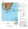
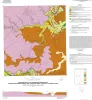
Geologic map of the Port Ingleside quadrangle, Texas Gulf coast | 2025 | Paine, J.G., Caudle, T.L., Morris, J.N., Grunau, B.A. | Open-File Map | Bureau of Economic Geology | |
|
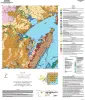
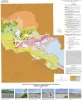
Geologic map of the Copano Bay area, Texas Gulf Coast | 2025 | Paine, J.G., Collins, E.W., Costard, L., Grunau, B.A., Morris, J.N., Caudle, T.L. | Open-File Map | Bureau of Economic Geology | |
|
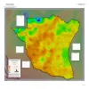
Geothermal Resources, South Texas | 2024 | A series of two 1:500,000 scale maps showing the Geothermal resources of South Texas. |
Andrews, J.R. | Open-File Map | Bureau of Economic Geology |
|
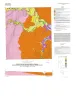
Geologic map of the Rincon Bend quadrangle, Aransas River and Copano Bay area, Texas Gulf of Mexico coast | 2015 | Paine, J.G., Collins, E.W., Costard, L. | Open-File Map | Bureau of Economic Geology | |
|
Geologic map of the Woodsboro quadrangle: Aransas and Mission Rivers, and Copano Bay area, Texas Gulf of Mexico Coast | 2015 | Paine, J.G., Collins, E.W., Costard, L. | Open-File Map | Bureau of Economic Geology | |
|
Geologic map of the Nueces Delta-Annaville and Odem quadrangles, Texas Gulf Coast | 2012 | Paine, J.G., Collins, E.W. | Open-File Map | Bureau of Economic Geology | |
|
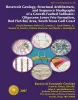
Reservoir Geology, Structural Architecture, and Sequence Stratigraphy of a Growth-Faulted Subbasin: Oligocene Lower Frio Formation, Red Fish Bay Area, South Texas Gulf Coast | 2007 | An integrated study using 3D seismic, wireline logs, and core analyses was conducted to establish new strategies for exploring compartmentalized, lowstand, prograding deltaic systems. |
Hammes, Ursula, Loucks, R.G., Brown, L.F., Jr., Treviño, R.H., Montoya, Patricia, Remington, R.L. | Report of Investigations | Bureau of Economic Geology |
|
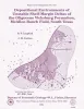
Depositional Environments of Unstable Shelf-Margin Deltas of the Oligocene Vicksburg Formation, McAllen Ranch Field, South Texas | 1994 | Cores and supporting petrophysical data from 20 wells in McAllen Ranch field were analyzed. |
Langford, R.P., Combes, J.M. | Report of Investigations | Bureau of Economic Geology |
|
Historical shoreline changes in Copano, Aransas, and Redfish Bays, Texas Gulf coast | 1993 | Shorelines bordering the bays of Texas are generally not as dynamic as those along the Gulf of Mexico. Nevertheless, the predominantly erosional movement of these bay shorelines translates to large losses of wetlands, arable uplands, and recreational and residential property. |
Paine, J.G., Morton, R.A. | Geological Circular | Bureau of Economic Geology |
|
Core and Log Analyses of Depositional Systems and Reservoir Properties ... in Frio, Vicksburg, and Wilcox Sandstones | 1992 | The Gas Research Institute, U.S. Department of Energy, and the State of Texas cooperated in joint-venture research to evaluate the infield reserve growth potential of mature gas fields containing conventional reservoirs. |
Levey, R.A., Grigsby, J.D. | Geological Circular | Bureau of Economic Geology |