Publications in Orange
| Title | Publication Year Sort ascending | Abstract | Author | Series | Publisher | |
|---|---|---|---|---|---|---|
|
Reference high-resolution correlation cross sections, Paleogene section, Texas coastal plain | 1994 | This cross section set traverses four Cenozoic depositional sub-provinces: the Rio Grande Embayment, San Marcos Arch, Houston Embayment, and Sabine Arch. |
Galloway, W.E., Liu, Xijin, Travis-Neuberger, Deborah, Xue, Liangquing | Cross Sections | Bureau of Economic Geology |
|
Hydrocarbon production and exploration potential of the distal Frio Formation, Texas Gulf coast and offshore | 1989 | Along the Texas Gulf shoreline and offshore, the distal margin of the Frio Formation is a deep hydrocarbon province that is underexplored relative to the onshore Frio. |
Hamlin, H.S. | Geological Circular | Bureau of Economic Geology |
|
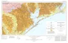
Submerged lands of Texas, Beaumont - Port Arthur area: sediments, geochemistry, benthic macroinvertebrates, and associated wetlands | 1987 | The State-owned submerged lands of Texas encompass almost 6,000 mi2 (15,540 km2). They lie below waters of the bay-estuary-lagoon system and the Gulf of Mexico and extend 10.3 mi (16.6 km) seaward from the Gulf shoreline (fig. 1). |
White, W.A., Calnan, T.R., Morton, R.A., Kimble, R.S., Littleton, T.G., McGowen, J.H., Nance, H.S. | Submerged Lands of Texas | Bureau of Economic Geology |

|
Structural cross sections, Tertiary formations, Texas Gulf Coast | 1981 | The publication comprises 24 structural dip cross sections, spaced 15 to 20 mi apart along the Texas coast, and 4 structural strike cross sections. Dip sections extend from near the Wilcox outcrop to the coastline. |
Dodge, M.M., Posey, J.S. | Cross Sections | Bureau of Economic Geology |
|
Sediment distribution, bathymetry, faults, and salt diapirs, submerged lands of Texas | 1979 | The State-owned submerged lands of Texas encompass nearly 6,000 square miles (15,540 km²) and extend from Mexico to Louisiana. The area includes the bays, estuaries, and lagoons, as well as the inner continental shelf 10.3 miles (16.6 km) seaward of the Gulf shoreline (fig. 1). |
McGowen, J.H., Morton, R.A. | Selected Reports | Bureau of Economic Geology |

|
Natural hazards of the Texas coastal zone | 1974 | The Texas Coastal Zone is marked by diversity in geography, resources, climate, and industry. |
Brown, L.F., Jr., Morton, R.A., McGowen, J.H., Kreitler, C.W., Fisher, W.L. | Selected Reports | Bureau of Economic Geology |
|
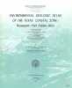
Environmental geologic Atlas of the Texas coastal zone -- Beaumont-Port Arthur area | 1973 | The Texas Coastal Zone is marked by diversity in geography, resources, climate, and industry. |
Fisher, W.L., Brown, L.F., Jr., McGowen, J.H., Groat, C.G. | Environmental Geologic Atlas of the Texas Coastal Zone | Bureau of Economic Geology |
|
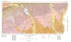
Geologic Atlas of Texas, Beaumont sheet (revised 1992) | 1968 | Geologic map that depicts the surface geology of Montgomery, San Jacinto, and Hardin Counties and parts of Madison, Trinity, Polk, Tyler, Jasper, Newton, Orange, Jefferson, Liberty, Harris, Waller, Grimes, Walker, and Robertson Counties. |
Barnes, V.E., Humble Oil and Refining Co., Shell Oil Co., Aronow, Saul, Shelby, C.A., Eargle, D.H., LeBlanc, R.J., Evans, F.G. | Geologic Atlas of Texas | Bureau of Economic Geology |
|
Geologic Atlas of Texas, Houston sheet (revised 1982) | 1968 | Geologic map that depicts the surface geology of Galveston and Chambers Counties and parts of Waller, Harris, Liberty, Jefferson, Orange, Brazoria, Matagorda, Wharton, and Fort Bend Counties. |
Barnes, V.E., Aronow, Saul, LeBlanc, R.J., Evans, F.G., Hinds, G.W., Holland, W.C., Van Siclen, D.C., Macon, J.W. | Geologic Atlas of Texas | Bureau of Economic Geology |