Publications in Morris
| Title | Publication Year Sort ascending | Abstract | Author | Series | Publisher | |
|---|---|---|---|---|---|---|
|
Suitability of salt domes in the east Texas basin for nuclear waste isolation: final summary of geologic and hydrologic research (1978 to 1983) | 1984 | This report summarizes results of the East Texas Waste Isolation (ETWI) program from January 1, 1978, to March 30, 1983. Having an extensive data base, the study comprised 33 different lines of research by 67 scientists and research assistants. |
Jackson, M.P.A., Seni, S.J. | Geological Circular | Bureau of Economic Geology |
|
Sedimentary record of Cretaceous and Tertiary salt movement, east Texas basin: times, rates, and volumes of salt flow and their implications for nuclear waste isolation and petroleum exploration | 1984 | Post-Aptian strata (younger than 112 ma) in the East Texas Basin were strongly influenced by halokinesis and recorded the evolution associated sate structures. |
Seni, S.J., Jackson, M.P.A. | Report of Investigations | Bureau of Economic Geology |

|
Depositional systems in the Nacatoch Formation (Upper Cretaceous), northeast Texas and southwest Arkansas | 1983 | The Nacatoch Formation of the East Texas Basin is the middle formation of the Navarro Group and consists of marine sandstones and mudstones derived largely from source areas to the northwest, north, and northeast of the East Texas Embayment. |
McGowan, M.K., Lopez, C.M. | Report of Investigations | Bureau of Economic Geology |
|
Fault tectonics of the east Texas basin | 1982 | Principal fault systems in the East Texas Basin were examined in terms of their distribution, geometry, displacement history, and possible origins. |
Jackson, M.P.A., Wilson, B.D. | Geological Circular | Bureau of Economic Geology |
|
Hydrocarbon accumulation patterns in the east Texas salt dome province | 1982 | Mobilization of the Louann Salt created the present structural configuration in the central part of the East Texas Basin and was the major control on hydrocarbon accumulation in the area. Salt-cored anticlines, turtle-structure anticlines, and salt diapirs were produced by flow of salt. |
Wood, D.H., Giles, A.B. | Geological Circular | Bureau of Economic Geology |
|
Ground-water hydraulics and hydrochemical facies in Eocene aquifers of the east Texas basin | 1982 | Eocene stratigraphic units in the East Texas Basin are composed of a thick sedimentary sequence (approximately 2,000 ft [600 m]) of fresh-water aquifers and aquitards covering an area of approximately 15,000 mi2 (51,000 km2). |
Fogg, G.E., Kreitler, C.W. | Report of Investigations | Bureau of Economic Geology |
|
Geology and geohydrology of the east Texas basin -- a report on the progress of nuclear waste isolation feasibility studies (1980) | 1981 | The third year of research was highlighted by the integration of regional basinal studies with growth histories for specific domes, studies of cap-rock diagenesis and salt deformation, preliminary studies of ground-water flow and geochemistry around Oakwood Dome, and preliminary studies of micros |
Kreitler, C.W., Collins, E.W., Davidson, E.D., Dix, O.R., Donaldson, G.A., Dutton, S.P., Fogg, G.E., Giles, A.B. | Geological Circular | Bureau of Economic Geology |
|
Geology and geohydrology of the east Texas basin -- a report on the progress of nuclear waste isolation feasibility studies (1979) | 1980 | Analysis during the second year was highlighted by a historical characterization of East Texas Basin infilling, the development of a model to explain the growth history of the domes, the continued studies of the Quaternary in East Texas, and a better understanding of the near-dome and regional hy |
Kreitler, C.W., Agagu, O.K., Basciano, J.M., Collins, E.W., Dix, O.R., Dutton, S.P., Fogg, G.E., Giles, A.B. | Geological Circular | Bureau of Economic Geology |

|
Environmental geology of the Wilcox Group lignite belt, east Texas | 1979 | This report provides a data base for decisions about lignite mining and reclamation in the Wilcox Group of East Texas. Kaiser (1974, 1978) estimates that about 12.2 billion short tons of potentially strip-minable lignite resources occur in East and South Texas. |
Henry, C.E., Basciano, J.M. | Report of Investigations | Bureau of Economic Geology |
|
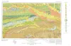
Geologic Atlas of Texas, Texarkana sheet (reprinted 1979 with base revised) | 1966 | Geologic map that depicts the surface geology of Lamar, Red River, Bowie, Delta, and Titus Counties and parts of Fannin, Hunt, Camp, Cass, Hopkins, Franklin, and Morris Counties, Texas. The 6-page booklet indicates geologic formations, abbreviations, and ages. |
Barnes, V.E., Humble Oil and Refining Co., Shell Oil Co., Pan American Petroleum Corp., Arkansas Geological and Conservation Commission, Oklahoma Geological Survey, McCallum, H.D., Wendlandt, E.A. | Geologic Atlas of Texas | Bureau of Economic Geology |