Publications in Jefferson
| Title | Publication Year Sort ascending | Abstract | Author | Series | Publisher | |
|---|---|---|---|---|---|---|
|
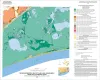
Geologic map of the High Island quadrangle, Texas Gulf of Mexico Coast | 2022 | Caudle, T.L., Paine, J.G., Andrews, J.R. | Open-File Map | Bureau of Economic Geology | |
|
Geologic map of the Mud Lake quadrangle, Texas Gulf of Mexico Coast | 2022 | Caudle, T.L., Paine, J.G. | Open-File Map | Bureau of Economic Geology | |
|
Geoenvironmental map of Big Hill Bayou quadrangle, Texas, Gulf of Mexico Coast | 2009 | Tremblay, T.A., Caudle, T.L., White, W.A. | Open-File Map | Bureau of Economic Geology | |
|
Geoenvironmental map of Port Arthur South quadrangle, Texas, Gulf of Mexico Coast | 2009 | Tremblay, T.A., Caudle, T.L., White, W.A. | Open-File Map | Bureau of Economic Geology | |
|
Geoenvironmental map of Clam Lake quadrangle, Texas, Gulf of Mexico Coast | 2009 | Tremblay, T.A., White, W.A., Caudle, T.L. | Open-File Map | Bureau of Economic Geology | |
|
Geoenvironmental map of Sabine Pass and Texas Point quadrangles, Texas, Gulf of Mexico Coast | 2009 | Tremblay, T.A., White, W.A., Caudle, T.L. | Open-File Map | Bureau of Economic Geology | |
|
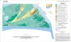
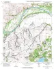
Geologic map of the Prairie Valley School quadrangle, Texas | 1999 | Collins, E.W. | Open-File Map | Bureau of Economic Geology | |
|
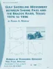
Gulf shoreline movement between Sabine Pass and the Brazos River, Texas: 1974 to 1996 | 1997 | Changes in shoreline position along the southeastern Texas Gulf coast between 1974 and 1996 were documented by conducting a kinematic real-time differential global positioning system (DGPS) field survey in 1996 and comparing that shoreline with other shorelines archived in a geographic informatio |
Morton, R.A. | Geological Circular | Bureau of Economic Geology |

|
Reference high-resolution correlation cross sections, Paleogene section, Texas coastal plain | 1994 | This cross section set traverses four Cenozoic depositional sub-provinces: the Rio Grande Embayment, San Marcos Arch, Houston Embayment, and Sabine Arch. |
Galloway, W.E., Liu, Xijin, Travis-Neuberger, Deborah, Xue, Liangquing | Cross Sections | Bureau of Economic Geology |
|
Core and Log Analyses of Depositional Systems and Reservoir Properties ... in Frio, Vicksburg, and Wilcox Sandstones | 1992 | The Gas Research Institute, U.S. Department of Energy, and the State of Texas cooperated in joint-venture research to evaluate the infield reserve growth potential of mature gas fields containing conventional reservoirs. |
Levey, R.A., Grigsby, J.D. | Geological Circular | Bureau of Economic Geology |