Publications in Guadalupe
| Title | Publication Year Sort ascending | Abstract | Author | Series | Publisher | |
|---|---|---|---|---|---|---|
|
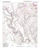
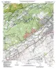
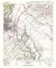
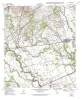
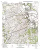
Geologic map of the Martindale quadrangle, Texas | 2002 | Collins, E.W. | Open-File Map | Bureau of Economic Geology | |
|
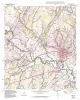
Geologic Map of the New Braunfels, Texas, 30x60 Minute Quadrangle | 2000 | Collins, E.W. | Miscellaneous Map | Bureau of Economic Geology | |
|
Geologic map of the Luling quadrangle, Texas | 1999 | Collins, E.W. | Open-File Map | Bureau of Economic Geology | |
|
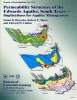
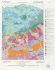
Permeability structure of the Edwards aquifer, south Texas -- implications for aquifer management | 1998 | This report describes the three-dimensional distribution of hydraulic conductivity in the Edwards aquifer from Kinney to Comal Counties, Texas. |
Hovorka, S.D., Mace, R.E., Collins, E.W. | Report of Investigations | Bureau of Economic Geology |
|
Edwards aquifer ground-water resources: geologic controls on porosity development in platform carbonates, south Texas | 1996 | Focusing on the highly developed Edwards aquifer, which supplies water for a large area of south-central Texas, this report presents a three-dimensional model of the porosity distribution in the aquifer, which quantifies the spatial distribution of water resources and provides information that ca |
Hovorka, S.D., Dutton, A.R., Ruppel, S.C., Yeh, J.S. | Report of Investigations | Bureau of Economic Geology |
|
Geologic map of the New Braunfels West quadrangle, Texas | 1993 | Collins, E.W. | Open-File Map | Bureau of Economic Geology | |
|
Geologic map of the New Braunfels East quadrangle, Texas | 1993 | Collins, E.W. | Open-File Map | Bureau of Economic Geology | |
|
Geologic map of the Marion Quadrangle, Texas | 1993 | Collins, E.W. | Open-File Map | Bureau of Economic Geology | |
|
Geologic map of the McQueeney Quadrangle, Texas | 1993 | Collins, E.W. | Open-File Map | Bureau of Economic Geology | |
|
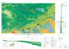
The Guadalupe - Lavaca - San Antonio - Nueces River basins regional study: San Antonio East - Llano East sheets | 1985 | Wermund, E.G., Gustavson, T.C., Garner, L.E., Morton, R.A., Woodruff, C.M., Jr., Macpherson, G.L., McKinney, L., Nilsson, J. | River Basins Regional Studies | Bureau of Economic Geology |