Publications in Grayson
| Title | Publication Year Sort ascending | Abstract | Author | Series | Publisher | |
|---|---|---|---|---|---|---|
|
Epeiric depositional models for the Lower Cretaceous Washita Group, north-central Texas | 1978 | The Washita Group in North-Central Texas and southeastern Oklahoma consists of up to 114 m of intercalated shale, limestone, and sandstone that accumulated in the shallow, epicontinental sea of the East Texas Basin. |
Scott, R.W., Fee, D., Magee, R., Laali, Hooman | Report of Investigations | Bureau of Economic Geology |
|
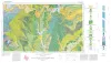
Geologic Atlas of Texas, Sherman sheet (revised 1991) | 1967 | Geologic map that depicts the surface geology of Montague, Cooke, Grayson, Wise, Denton, and Collin Counties and parts of Jack, Fannin, Hunt, and Clay Counties, Texas. The 16-page booklet indicates geologic formations, abbreviations, and ages. |
McGowen, J.H., Hentz, T.F., Owen, D.E., Pieper, M.K., Shelby, C.A., Barnes, V.E., Humble Oil and Refining Co., Pure Oil Co. | Geologic Atlas of Texas | Bureau of Economic Geology |
|
The geology of Grayson County, Texas | 1931 | Bullard, F.M. | UT Bulletin | ||
|
Underground waters and subsurface temperatures of the Woodbine sand in northeast Texas | 1931 | Plummer, F.B., Sargent, E.C. | UT Bulletin | ||
|
Paleontological correlation of the Fredericksburg and Washita Formations in north Texas | 1919 | Adkins, W.S., Winton, W.M. | UT Bulletin |