Publications in Goliad
| Title | Publication Year Sort ascending | Abstract | Author | Series | Publisher | |
|---|---|---|---|---|---|---|
|
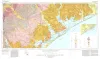
Geologic Atlas of Texas, Beeville-Bay City sheet (revised 1987) | 1975 | Geologic map that depicts the surface geology of Goliad, Refugio, and Calhoun Counties and parts of Karnes, De Witt, Victoria, Jackson, Matagorda, Aransas, San Patricio, Bee, and Live Oak Counties. The 4-page booklet indicates geologic formations, abbreviations, and ages. |
Barnes, V.E., Brown, T.E., Brewton, J.L., Aronow, Saul, Eargle, D.H., Morton, R.G., Maxson, M.J., Wyeth, J.C. | Geologic Atlas of Texas | Bureau of Economic Geology |
|
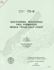
Geothermal resources, Frio Formation, middle Texas Gulf coast | 1975 | Knowledge of the regional sand distribution and its relationship to formation temperature and pressure is a preliminary step in evaluating the geothermal resources of the Frio Formation. |
Bebout, D.G., Agagu, O.K., Dorfman, M.H. | Geological Circular | Bureau of Economic Geology |
|
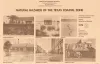
Natural hazards of the Texas coastal zone | 1974 | The Texas Coastal Zone is marked by diversity in geography, resources, climate, and industry. |
Brown, L.F., Jr., Morton, R.A., McGowen, J.H., Kreitler, C.W., Fisher, W.L. | Selected Reports | Bureau of Economic Geology |
|
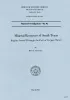
Mineral resources of south Texas: region served through the port of Corpus Christi | 1962 | This report is a compilation of all available data on mineral resources (exclusive of oil and gas) in 39 south Texas counties. Information from published and unpublished sources was checked and supplemented by field investigations. |
Maxwell, R.A. | Report of Investigations | Bureau of Economic Geology |