Publications in Gillespie
| Title | Publication Year Sort ascending | Abstract | Author | Series | Publisher | |
|---|---|---|---|---|---|---|
|
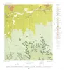
Geology of the Cave Creek School Quadrangle, Gillespie County, Texas | 1967 | Barnes, V.E. | Geologic Quadrangle Map | Bureau of Economic Geology | |
|
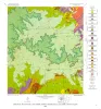
Geology of the Hye Quadrangle, Blanco, Gillespie, and Kendall Counties, Texas | 1965 | Hye quadrangle includes part of the southeastern Llano region and part of the eastern margin of the Edwards Plateau where most of the Plateau surface has been destroyed by erosion. |
Barnes, V.E. | Geologic Quadrangle Map | Bureau of Economic Geology |
|
Geology of the Rocky Creek Quadrangle, Blanco and Gillespie Counties, Texas | 1965 | Barnes, V.E. | Geologic Quadrangle Map | Bureau of Economic Geology | |
|
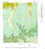
Geology of the Stonewall Quadrangle, Gillespie and Kendall Counties, Texas | 1965 | Stonewall quadrangle includes part of the southern margin of the Llano region and part of the eastern margin of the Edwards Plateau where most of the plateau suriace has been destroyed by erosion. |
Barnes, V.E. | Geologic Quadrangle Map | Bureau of Economic Geology |
|
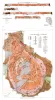
Geologic map of Southeastern Llano Uplift, Llano, Burnet, Blanco, and Gillespie counties, Texas | 1963 | McGehee, R.V. | Miscellaneous Map | Bureau of Economic Geology | |

|
Upper Franconian and Lower Trempealeauan Cambrian trilobites and brachiopods, Wilberns Formation, central Texas | 1962 | Forty-three species belonging to 28 genera, 12 species of brachipods belonging to 8 genera, and 1 species of gastropods are described from the Morgan Creek, Point Peak, and San Saba Members of the Wilberns Formation in the Llano Uplift. |
Bell, W.C., Ellinwood, H.L. | Report of Investigations | Bureau of Economic Geology |
|
Vermiculite in central Texas | 1959 | Vermiculite deposits in the Central Mineral region of Texas, chiefly in Precambrian metamorphic rocks, are situated in Llano County and adjacent parts of Mason, Gillespie, and Burnet counties with minor occurrences in Blanco and San Saba counties. |
Clabaugh, S.E., Barnes, V.E. | Report of Investigations | Bureau of Economic Geology |

|
Devonian - Mississippian transition in central Texas | 1957 | The Devonian-Mississippian transition outcrops of central Texas are here described summarily and assigned to a new stratigraphic unit, the Houy Formation. The beds included are mainly Upper Devonian, but partly Lower Mississippian. Locally a basal fraction may be Middle Devonian. |
Cloud, P.E., Jr., Barnes, V.E., Hass, W.H. | Report of Investigations | Bureau of Economic Geology |
|
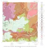
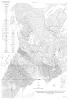
Geologic map of the Fall Prong Quadrangle, Kimble, Gillespie and Mason Counties, Texas | 1956 | Fall Prong quadrangle is in the marginal portion of the Edwards Plateau near the southeastern corner of the Llano region. Almost three-quarters of the quadrangle is within the Edwards Plateau, and the rest consists of valleys of the Llano basin cutting back into the plateau. |
Barnes, V.E. | Geologic Quadrangle Map | Bureau of Economic Geology |
|
Enchanted rock batholith, Llano and Gillespie Counties, Texas | 1956 | Hutchinson, R.M. | Miscellaneous Map | Bureau of Economic Geology |