Publications in Gillespie
| Title | Publication Year Sort ascending | Abstract | Author | Series | Publisher | |
|---|---|---|---|---|---|---|
| |
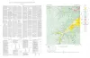
Map showing correlation of geologic, gravity, and magnetic observations, Blanco and Gillespie Counties, Texas | 1955 | Barnes, V.E., Romberg, Frederick, Anderson, W.A. | Miscellaneous Map | Bureau of Economic Geology | |
|
Geologic map of the Wendel Quadrangle, Kimble, Kerr, and Gillespie Counties, Texas | 1954 | Wendel quadrangle is entirely within the Edwards Plateau province and is situated southwest of the Llano region. |
Barnes, V.E. | Geologic Quadrangle Map | Bureau of Economic Geology |
|
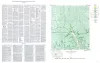
Geologic map of the Harper quadrangle, Gillespie County, Texas | 1954 | Harper quadrangle is in the Edwards Plateau province south of the Llano region. The plateau surface within the quadrangle is dissected by the Pedernales River and its tributaries in the southern part, and by Threadgill and Edwards Creeks in the northern part. |
Barnes, V.E. | Geologic Quadrangle Map | Bureau of Economic Geology |
|
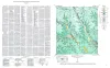
Geologic map of the Dry Branch quadrangle, Gillespie and Kerr Counties, Texas | 1954 | Dry Branch quadrangle is in the Edwards Plateau province southwest of the Llano region. |
Barnes, V.E. | Geologic Quadrangle Map | Bureau of Economic Geology |
|
Geologic map of the Klein Branch quadrangle, Gillespie and Kerr Counties, Texas | 1954 | Barnes, V.E. | Geologic Quadrangle Map | Bureau of Economic Geology | |
|
Geologic map of the Threadgill Creek quadrangle, Gillespie and Kerr Counties, Texas | 1954 | Barnes, V.E. | Geologic Quadrangle Map | Bureau of Economic Geology | |
|
Geologic map of the Spring Creek Quadrangle, Gillespie County, Texas | 1952 | Barnes, V.E. | Geologic Quadrangle Map | Bureau of Economic Geology | |
|
Geologic map of the Live Oak Creek Quadrangle, Gillespie County, Texas | 1952 | Barnes, V.E. | Geologic Quadrangle Map | Bureau of Economic Geology | |
|
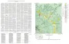
Geologic map of the Palo Alto Creek Quadrangle, Gillespie County, Texas | 1952 | Palo Alto Creek quadrangle is south of the Llano region and is in the marginal portion of the Edwards Plateau where much of the plateau surface has been destroyed by erosion. |
Barnes, V.E. | Geologic Quadrangle Map | Bureau of Economic Geology |
|
Geologic map of the Gold Quadrangle, Gillespie County, Texas | 1952 | Barnes, V.E. | Geologic Quadrangle Map | Bureau of Economic Geology |