Publications in Frio
| Title | Publication Year Sort ascending | Abstract | Author | Series | Publisher | |
|---|---|---|---|---|---|---|
|
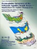
Permeability structure of the Edwards aquifer, south Texas -- implications for aquifer management | 1998 | This report describes the three-dimensional distribution of hydraulic conductivity in the Edwards aquifer from Kinney to Comal Counties, Texas. |
Hovorka, S.D., Mace, R.E., Collins, E.W. | Report of Investigations | Bureau of Economic Geology |
|
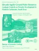
Edwards aquifer ground-water resources: geologic controls on porosity development in platform carbonates, south Texas | 1996 | Focusing on the highly developed Edwards aquifer, which supplies water for a large area of south-central Texas, this report presents a three-dimensional model of the porosity distribution in the aquifer, which quantifies the spatial distribution of water resources and provides information that ca |
Hovorka, S.D., Dutton, A.R., Ruppel, S.C., Yeh, J.S. | Report of Investigations | Bureau of Economic Geology |
|
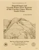
Depositional and ground-water flow systems of the Carrizo - Upper Wilcox, south Texas | 1988 | In the Rio Grande Embayment of South Texas, the Carrizo Formation (lower Eocene) consists of two sand-rich fluvial depositional systems that grade basinward into several deltaic complexes within the upper part of the Wilcox Group. |
Hamlin, H.S. | Report of Investigations | Bureau of Economic Geology |
|
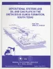
Depositional systems and oil and gas plays in the Cretaceous Olmos Formation, south Texas | 1986 | The Upper Cretaceous Olmos Formation in South Texas continues to be an active exploration target 60 years after oil was first discovered in this clastic assemblage. The shallow, oil-bearing formation was deposited on a broad, wave-influenced shelf. Sand accumulated in two depocenters. |
Tyler, Noel, Ambrose, W.A. | Report of Investigations | Bureau of Economic Geology |

|
Structural cross sections, Tertiary formations, Texas Gulf Coast | 1981 | The publication comprises 24 structural dip cross sections, spaced 15 to 20 mi apart along the Texas coast, and 4 structural strike cross sections. Dip sections extend from near the Wilcox outcrop to the coastline. |
Dodge, M.M., Posey, J.S. | Cross Sections | Bureau of Economic Geology |
|
Depositional and diagenetic history of the Sligo and Hosston Formations(Lower Cretaceous) in south Texas | 1981 | The Sligo and Hosston Formations of Aptian age occur over thousands of square miles in the subsurface of South Texas. |
Bebout, D.G., Budd, D.A., Schatzinger, R.A. | Report of Investigations | Bureau of Economic Geology |
|
Smackover and lower Buckner Formations, south Texas: depositional systems on a Jurassic carbonate ramp | 1981 | The Smackover and lower part of the Buckner Formations (Oxfordian) comprise a thick regressive sedimentary sequence deposited on a Jurassic carbonate ramp. Four major depositional systems are recognized: (1) basinal, (2) low-energy open shelf, (3) high-energy shoal, and (4) sabkha. |
Budd, D.A., Loucks, R.G. | Report of Investigations | Bureau of Economic Geology |
|
Wave-dominated delta systems of the Upper Cretaceous San Miguel Formation, Maverick Basin, south Texas | 1980 | Upward-coarsening sandstone units of the Upper Cretaceous San Miguel Formation in South Texas were deposited in wave-dominated deltas during minor regressive phases, periodically interrupting a major marine transgression. |
Weise, B.R. | Report of Investigations | Bureau of Economic Geology |
|
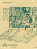
Geologic Atlas of Texas, Crystal City-Eagle Pass sheet | 1976 | Oversize color geologic map that depicts surface geology of Dimmit, LaSalle, and McMullen Counties and parts of Maverick, Zavala, Frio, Atascosa, Karnes, Wilson, Live Oak, Jim Wells, Duval, and Webb Counties, Texas. The 6-page booklet indicates geologic formations, abbreviations, and ages. |
Barnes, V.E., Humble Oil and Refining Co., Shell Oil Co., Amerada Petroleum Corp., Mobil Oil Co., Owens, Frith, Howeth, Ike, Brown, T.E. | Geologic Atlas of Texas | Bureau of Economic Geology |
|
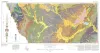
Geologic Atlas of Texas, San Antonio sheet (revised 1982) | 1974 | Geologic map that depicts the surface geology of Comal, Bandera, Bexar, and Medina Counties and parts of Real, Kerr, Kendall, Hays, Guadalupe, Wilson, Atascosa, Frio, Zavala, and Uvalde Counties, Texas. The 9-page booklet indicates geologic formations, abbreviations, and ages. |
Barnes, V.E., Shell Oil Co., Amerada Petroleum Corp., Brown, T.E., Waechter, N.B., Dillon, R.L. | Geologic Atlas of Texas | Bureau of Economic Geology |