Publications in Fayette
| Title | Publication Year Sort ascending | Abstract | Author | Series | Publisher | |
|---|---|---|---|---|---|---|
|
A systematic approach to identifying hydrocarbon sweet spots using integrated seismic multiattribute, wireline-log, and core analyses: case study from the Upper Cretaceous Taylor Serbin field, southeast Texas | 2021 | Ogiesoba, O. C., Ambrose, W.A. | Report of Investigations | Bureau of Economic Geology | |
|
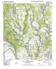
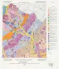
Geologic map of the Winchester quadrangle, Texas | 2001 | Collins, E.W. | Open-File Map | Bureau of Economic Geology | |
|
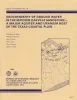
Groundwater availability in the Carrizo-Wilcox aquifer in central Texas -- numerical simulations of 2000 through 2050 withdrawal projections | 1999 | Between 1951 and 1996, groundwater pumpage from the Carrizo-Wilcox aquifer, one of Texas' major aquifer systems, increased in the area between the Colorado and Brazos Rivers from approximately 10,600 to 37,900 acre-ft/yr, primarily as a result of mining needs. |
Dutton, A.R. | Report of Investigations | Bureau of Economic Geology |
|
The Wilcox Group and Carrizo Sand (Paleogene) in east-central Texas: depositional systems and deep-basin lignite | 1985 | Ayers Jr., W.B., Lewis, A.H., Bissett, F.H., Mazza, D.B., Prouty, D.A., Reutter, D.C., Sutley, A.M. | Geological Folios | Bureau of Economic Geology | |
|
The Guadalupe - Lavaca - San Antonio - Nueces River basins regional study: Seguin West - Austin West sheets | 1985 | Wermund, E.G., Gustavson, T.C., Morton, R.A., Woodruff, C.M., Jr., Macpherson, G.L., McKinney, L., Nilsson, J., Waddell, C.T. | River Basins Regional Studies | Bureau of Economic Geology | |
|
Geochemistry of ground water in the Miocene Oakville Sandstone -- a major aquifer and uranium host of the Texas coastal plain | 1982 | The Oakville Sandstone is a major aquifer and a major host of uranium deposits in the Texas Coastal Plain. |
Henry, C.D., Galloway, W.E., Smith, G.E., Ho, C.L., Morton, J.P., Gluck, J.K. | Report of Investigations | Bureau of Economic Geology |
|
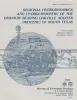
Regional hydrodynamics and hydrochemistry of the uranium-bearing Oakville aquifer (Miocene) of south Texas | 1982 | The Oakville Formation consists of sediments deposited by several major fluvial systems that traversed the Texas Coastal Plain during the Miocene Epoch. |
Smith, G.E., Galloway, W.E., Henry, C.D., Gluck, J.K., McIntyre, J.F., Pisasale, E.T., Spradlin, S.D. | Report of Investigations | Bureau of Economic Geology |
|
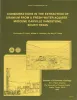
Considerations in the extraction of uranium from a fresh-water aquifer -- Miocene Oakville Sandstone, south Texas | 1982 | The Miocene Oakville Sandstone is a major aquifer and uranium host beneath the Texas Coastal Plain. In 1976, approximately 6,000 acre-ft of ground water were withdrawn from the Oakville for municipal use. |
Henry, C.D., Galloway, W.E., Smith, G.E., Childs, C.S., Devine, P.E., Dutton, A.R., Gluck, J.K., McIntyre, J.F. | Report of Investigations | Bureau of Economic Geology |
|
Environmental geology of the Yegua - Jackson lignite belt, southeast Texas | 1982 | Environmental geologic maps of the Texas lignite belt were prepared in response to renewed production of lignite in Texas and enactment of Federal and State laws governing coal and lignite surface mining. |
Jackson, M.L.W., Garner, L.E., Sharpe, R.D. | Report of Investigations | Bureau of Economic Geology |
|
Depositional framework, hydrostratigraphy, and uranium mineralization of the Oakville Sandstone (Miocene), Texas coastal plain | 1982 | The Oakville Sandstone (Miocene) of the Texas Coastal Plain comprises a major sand-rich fluvial system composed of deposits of several major and minor rivers that originated within Texas and surrounding states. |
Galloway, W.E., Henry, C.D., Smith, G.E. | Report of Investigations | Bureau of Economic Geology |