Publications in El Paso
| Title | Publication Year Sort ascending | Abstract | Author | Series | Publisher | |
|---|---|---|---|---|---|---|
|
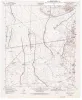
Geologic map of the Nations South Well quadrangle, Texas | 1995 | Collins, E.W. | Open-File Map | Bureau of Economic Geology | |
|
Geologic map of the San Elizario quadrangle, Texas | 1995 | Collins, E.W. | Open-File Map | Bureau of Economic Geology | |
|
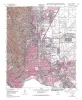
Geologic map of the El Paso Quadrangle, Texas | 1994 | Collins, E.W., Raney, J.A. | Open-File Map | Bureau of Economic Geology | |
|
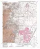
Geologic map of the North Franklin Mountain Quadrangle, Texas | 1994 | Raney, J.A., Collins, E.W. | Open-File Map | Bureau of Economic Geology | |
|
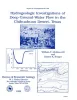
Hydrogeologic investigations of deep ground-water flow in the Chihuahuan Desert, Texas | 1992 | Regional and local hydrologic investigations were conducted in Trans-Pecos Texas as part of a study to evaluate potential sites for a low-level radioactive waste repository. |
Mullican, W.F., Senger, R.K. | Report of Investigations | Bureau of Economic Geology |
|
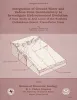
Tertiary and Quaternary structure and paleotectonics of the Hueco Basin, Trans-Pecos Texas and Chihuahua, Mexico | 1991 | The Hueco Basin of Trans-Pecos Texas, which formed in response to Cenozoic extensional tectonism, lies within the southern Rio Grande rift near the poorly defined boundary between the rift and the southern Basin and Range province. |
Collins, E.W., Raney, J.A. | Geological Circular | Bureau of Economic Geology |
|
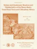
Integration of ground-water and vadose-zone geochemistry to investigate hydrochemical evolution: a case study in arid lands of the northern Chihuahuan Desert, Trans-Pecos Texas | 1990 | The hydrochemical history of ground water in the arid southeastern Hueco Bolson and southwestern Diablo Plateau was investigated by collecting soil-moisture samples from unsaturated siliciclastic bolson-fill sediments and groundwater samples from the Diablo Plateau aquifer, the Hueco Bolson silt |
Fisher, R.S., Mullican, W.F. | Geological Circular | Bureau of Economic Geology |
|
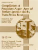
Compilation of potassium-argon ages of Tertiary igneous rocks, Trans-Pecos Texas | 1986 | This compilation of potassium-argon (K-Ar) ages of igneous rocks of the Tertiary volcanic field of Trans-Pecos Texas includes all published ages known to us as well as many unpublished results. |
Henry, C.D., McDowell, F.W., Price, J.G., Smyth, R.C. | Geological Circular | Bureau of Economic Geology |
|
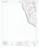
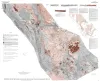
Tectonic map of the Basin and Range Province of Texas and adjacent Mexico | 1985 | Henry, C.D., Price, J.G., Gluck, J.K., Bockoven, N.T. | Miscellaneous Map | Bureau of Economic Geology | |
|
Annotated bibliography of mineral deposits in Trans-Pecos Texas | 1983 | Price, J.G., Henry, C.D., Standen, A.R. | Mineral Resource Circular | Bureau of Economic Geology |