|
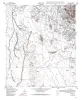
Geologic map of the Nations East Well quadrangle, Texas |
1995 |
|
Collins, E.W. |
Open-File Map |
Bureau of Economic Geology |
|
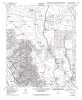
Geologic map of the Nations South Well quadrangle, Texas |
1995 |
|
Collins, E.W. |
Open-File Map |
Bureau of Economic Geology |
|
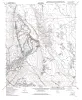
Geologic map of the San Elizario quadrangle, Texas |
1995 |
|
Collins, E.W. |
Open-File Map |
Bureau of Economic Geology |
|
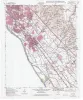
Geologic map of the Clint quadrangle, Texas |
1995 |
|
Collins, E.W., Raney, J.A. |
Open-File Map |
Bureau of Economic Geology |
|
Geologic map of the Clint NE quadrangle, Texas |
1995 |
|
Collins, E.W., Raney, J.A. |
Open-File Map |
Bureau of Economic Geology |
|
Geologic map of the Clint NW quadrangle, Texas |
1995 |
|
Collins, E.W., Raney, J.A. |
Open-File Map |
Bureau of Economic Geology |
|
Geologic map of the Clint SE quadrangle, Texas |
1995 |
|
Collins, E.W., Raney, J.A. |
Open-File Map |
Bureau of Economic Geology |
|
Geologic map of the Ysleta quadrangle, Texas |
1995 |
|
Collins, E.W., Raney, J.A. |
Open-File Map |
Bureau of Economic Geology |
|
Geologic map of the Fort Bliss NE Quadrangle, Texas |
1995 |
|
Collins, E.W. |
Open-File Map |
Bureau of Economic Geology |
|
Geologic map of the Fort Bliss SE Quadrangle, Texas |
1995 |
|
Collins, E.W. |
Open-File Map |
Bureau of Economic Geology |