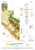
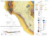
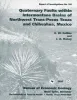
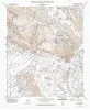
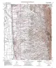
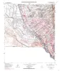
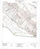
Publication Search

Publications in El Paso

Title Publication Year Abstract Author Series Publisher
Geologic Atlas of Texas, Van Horn-El Paso sheet (revised 1983) Geologic Atlas of Texas, Van Horn-El Paso sheet (revised 1983) 1968

Geologic map that depicts the surface geology of El Paso County and parts of Hudspeth. Jeff Davis, and Culberson Counties, Texas. The 12-page booklet indicates geologic formations, abbreviations, and ages. Published in honor of E.

Barnes, V.E., Shell Oil Co., Cities Service Petroleum Co., Dietrich, J.W., Owen, D.E., Shelby, C.A., Macon, J.W., Bridges, L.W. Geologic Atlas of Texas Bureau of Economic Geology
A preliminary assessment of the geologic setting, hydrology, and geochemistry of the Hueco Tanks geothermal area, Texas and New Mexico A preliminary assessment of the geologic setting, hydrology, and geochemistry of the Hueco Tanks geothermal area, Texas and New Mexico 1981

The Hueco Tanks geothermal area contains five known but now inactive hot wells (50° to 71°C). The area trends north-south along the east side of Tularosa-Hueco Bolson astride the Texas-New Mexico border approximately 40 km northeast of El Paso.

Henry, C.D., Gluck, J.K. Geological Circular Bureau of Economic Geology
Compilation of potassium-argon ages of Tertiary igneous rocks, Trans-Pecos Texas Compilation of potassium-argon ages of Tertiary igneous rocks, Trans-Pecos Texas 1986

This compilation of potassium-argon (K-Ar) ages of igneous rocks of the Tertiary volcanic field of Trans-Pecos Texas includes all published ages known to us as well as many unpublished results.

Henry, C.D., McDowell, F.W., Price, J.G., Smyth, R.C. Geological Circular Bureau of Economic Geology
Integration of ground-water and vadose-zone geochemistry to investigate hydrochemical evolution: a case study in arid lands of the northern Chihuahuan Desert, Trans-Pecos Texas Integration of ground-water and vadose-zone geochemistry to investigate hydrochemical evolution: a case study in arid lands of the northern Chihuahuan Desert, Trans-Pecos Texas 1990

The hydrochemical history of ground water in the arid southeastern Hueco Bolson and southwestern Diablo Plateau was investigated by collecting soil-moisture samples from unsaturated siliciclastic bolson-fill sediments and groundwater samples from the Diablo Plateau aquifer, the Hueco Bolson silt

Fisher, R.S., Mullican, W.F. Geological Circular Bureau of Economic Geology
Tertiary and Quaternary structure and paleotectonics of the Hueco Basin, Trans-Pecos Texas and Chihuahua, Mexico Tertiary and Quaternary structure and paleotectonics of the Hueco Basin, Trans-Pecos Texas and Chihuahua, Mexico 1991

The Hueco Basin of Trans-Pecos Texas, which formed in response to Cenozoic extensional tectonism, lies within the southern Rio Grande rift near the poorly defined boundary between the rift and the southern Basin and Range province.

Collins, E.W., Raney, J.A. Geological Circular Bureau of Economic Geology
Annotated bibliography of mineral deposits in Trans-Pecos Texas Annotated bibliography of mineral deposits in Trans-Pecos Texas 1983 Price, J.G., Henry, C.D., Standen, A.R. Mineral Resource Circular Bureau of Economic Geology
Geological map of a portion of west Texas Geological map of a portion of west Texas 1904 Hill, B.F., Udden, J.A. Miscellaneous Map Bureau of Economic Geology
Tectonic map of the Basin and Range Province of Texas and adjacent Mexico Tectonic map of the Basin and Range Province of Texas and adjacent Mexico 1985 Henry, C.D., Price, J.G., Gluck, J.K., Bockoven, N.T. Miscellaneous Map Bureau of Economic Geology
Geologic Map of West Hueco Bolson, El Paso Region, Texas Geologic Map of West Hueco Bolson, El Paso Region, Texas 2000 Collins, E.W., Raney, J.A. Miscellaneous Map Bureau of Economic Geology
Geologic map of the central Hueco Bolson, Acala - Fort Hancock - Esperanza region, Texas Geologic map of the central Hueco Bolson, Acala - Fort Hancock - Esperanza region, Texas 2002 Collins, E.W., Raney, J.A. Miscellaneous Map Bureau of Economic Geology