Publications in Duval
| Title | Publication Year Sort ascending | Abstract | Author | Series | Publisher | |
|---|---|---|---|---|---|---|
|
Upper Tertiary and Quaternary depositional systems, central coastal plain, Texas -- regional geology of the coastal aquifer and potential liquid-waste repositories | 1981 | Upper Miocene, Pliocene, and Pleistocene deposits in the subsurface of the central Coastal Plain of Texas were subdivided into six operational units comprising the surface-defined Fleming, Goliad, Willis, Lissie, and Beaumont Formations. |
Solis-Iriarte, R.F. | Report of Investigations | Bureau of Economic Geology |
|
Depositional and diagenetic history of the Sligo and Hosston Formations(Lower Cretaceous) in south Texas | 1981 | The Sligo and Hosston Formations of Aptian age occur over thousands of square miles in the subsurface of South Texas. |
Bebout, D.G., Budd, D.A., Schatzinger, R.A. | Report of Investigations | Bureau of Economic Geology |
|
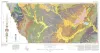
Geologic Atlas of Texas, Crystal City-Eagle Pass sheet | 1976 | Oversize color geologic map that depicts surface geology of Dimmit, LaSalle, and McMullen Counties and parts of Maverick, Zavala, Frio, Atascosa, Karnes, Wilson, Live Oak, Jim Wells, Duval, and Webb Counties, Texas. The 6-page booklet indicates geologic formations, abbreviations, and ages. |
Barnes, V.E., Humble Oil and Refining Co., Shell Oil Co., Amerada Petroleum Corp., Mobil Oil Co., Owens, Frith, Howeth, Ike, Brown, T.E. | Geologic Atlas of Texas | Bureau of Economic Geology |

|
South Texas uranium province: geology and extraction | 1976 | The increasing demand for uranium combined with the improving economics of uranium production have resulted in a significant upsurge in exploration and mining efforts in the South Texas Coastal Plain uranium province. Texas ranks third in U.S. uranium production. |
Galloway, W.E., Groat, C.G. | Research Note | |
|
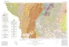
Geologic Atlas of Texas, Laredo sheet | 1976 | Geologic map that depicts the surface geology of parts of Webb, Duval, Jim Wells, Kleberg, Brooks, Jim Hogg, and Zapata Counties |
Barnes, V.E., Mobil Oil Co., Shell Oil Co., Humble Oil and Refining Co., Owens, Frith, Brewton, J.L., Tobin, Edward, Martin, R.G. | Geologic Atlas of Texas | Bureau of Economic Geology |

|
Geothermal resources, Frio Formation, South Texas | 1974 | A preliminary study of the Frio sand distribution and formation temperatures and pressures was undertaken in order to define prospective areas in which a more detailed reservoir analysis is necessary prior to the selection of a site for a geothermal well. |
Bebout, D.G., Dorfman, M.H., Agagu, O.K., Granata, G.E., Sanders, G.B. | Geological Circular | Bureau of Economic Geology |

|
Lithology and petrology of the Gueydan (Catahoula) Formation in south Texas | 1968 | Tuff, tuffaceous sand and clay, bentonite, and sandstone containing abundant volcanic rock detritus are present in Gulf Coast Tertiary rocks ranging in age from Eocene to Pliocene. |
McBride, E.F., Lindemann, W.L., Freeman, P.S. | Report of Investigations | Bureau of Economic Geology |

|
Mineral resources of south Texas: region served through the port of Corpus Christi | 1962 | This report is a compilation of all available data on mineral resources (exclusive of oil and gas) in 39 south Texas counties. Information from published and unpublished sources was checked and supplemented by field investigations. |
Maxwell, R.A. | Report of Investigations | Bureau of Economic Geology |

|
The Gueydan, a new Middle Tertiary formation from the southwestern coastal plain of Texas | 1926 | Bailey, T.L. | UT Bulletin |