Publications in Briscoe
| Title | Publication Year Sort ascending | Abstract | Author | Series | Publisher | |
|---|---|---|---|---|---|---|
|
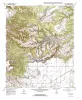
Geologic map of the Lake Theo Quadrangle, Texas | 1998 | Collins, E.W. | Open-File Map | Bureau of Economic Geology | |
|
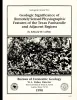
Geologic Significance of Remotely Sensed Physiographic Features of the Texas Panhandle and Adjacent Regions | 1990 | Remotely sensed features such as linear drainages, escarpments, ridges, and aligned playas have been identified on Landsat imagery (scale 1:250,000) of the Texas Panhandle and adjacent regions to allow comparison of these features with detailed regional and site-specific geologic data. |
Collins, E.W. | Geological Circular | Bureau of Economic Geology |
|
Tertiary and Quaternary stratigraphy and vertebrate paleontology of parts of northwestern Texas and eastern New Mexico | 1990 | This field guide summarizes recent interpretations of the upper Cenozoic stratigraphy of parts of the Southern High Plains and Rolling Plains in northwestern Texas and eastern New Mexico. |
Gustavson, T.C., Holliday, V.T., Osterkamp, W.R., Schultz, G.E., Winkler, D.A. | Guidebook | Bureau of Economic Geology |
|
Lithogenetic stratigraphy of the Triassic Dockum Formation, Palo Duro basin, Texas | 1989 | Four clastic depositional sequences compose the lower part of the Triassic Dockum Formation in the Palo Duro Basin. |
Johns, D.A. | Report of Investigations | Bureau of Economic Geology |
|
Tectonic structures of the Palo Duro basin, Texas panhandle | 1989 | The Palo Duro Basin is a broad structural low in the southern Texas Panhandle that formed as a result of nearly continuous Pennsylvanian and Permian subsidence. True complexity of this basin is unknown because of the sparsity of structural information. |
Budnik, R.T. | Report of Investigations | Bureau of Economic Geology |
|
Stratigraphy and influence of effective porosity on ground-water flow in the Wolfcamp brine aquifer, Palo Duro basin, Texas panhandle | 1988 | In the Palo Duro Basin, the Wolfcampian Series (lower Permian) overlies Pennsylvanian (primarily Virgilian) strata and underlies the Wichita Group (Leonardian). |
Conti, R.D., Herron, M.J., Senger, R.K., Wirojanagud, Prakob | Report of Investigations | Bureau of Economic Geology |

|
Hydrogeology and hydrochemistry of the Ogallala aquifer, southern High Plains, Texas panhandle and eastern New Mexico | 1988 | The Ogallala aquifer, which underlies the Southern High Plains, consists of the saturated sediments of the Neogene Ogallala Formation. The aquifer is the main source of water for the High Plains of Texas and New Mexico and is being severely depleted by extensive pumpage for irrigation. |
Nativ, Ronit | Report of Investigations | Bureau of Economic Geology |
|
Geomorphic processes and rates of retreat affecting the Caprock Escarpment, Texas panhandle | 1988 | The interaction of geomorphic and ground-water processes has produced the Caprock Escarpmentthat bounds the eastern margin of the Southern High Plains in the Texas Panhandle. |
Gustavson, T.C., Simpkins, W.W. | Report of Investigations | Bureau of Economic Geology |
|
Hydrogeologic and hydrochemical properties of salt-dissolution zones, Palo Duro basin, Texas panhandle - preliminary assessment | 1987 | Ground water that moves downward from aquifers in clastic rocks of the Triassic Dockum Group and Neogene Ogallala Formation dissolves bedded halite and anhydrite in the Upper Permian evaporite section along the perimeter of the Southern High Plains in the Texas Panhandle. |
Dutton, A.R. | Geological Circular | Bureau of Economic Geology |
|
Cyclicity in the Middle Permian San Andres Formation, Palo Duro Basin, Texas panhandle | 1986 | The San Andres Formation in the Palo Duro Basin is a middle Permian carbonate-evaporite sequence situated between two red-bed units, the underlying Glorieta and the overlying undifferentiated Queen-Grayburg sequences. |
Fracasso, M.A., Hovorka, S.D. | Report of Investigations | Bureau of Economic Geology |