Publications in Bosque
| Title | Publication Year Sort ascending | Abstract | Author | Series | Publisher | |
|---|---|---|---|---|---|---|
|
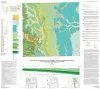
Geologic map of the east part of Cleburne, Texas, 30 x 60 minute quadrangle: South Fort Worth-Interstate 35W corridor | 2011 | Collins, E.W., Baumgardner, R.W., Jr. | Miscellaneous Map | Bureau of Economic Geology | |

|
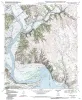
Geologic map of the Brazos Point quadrangle, Texas | 2010 | Collins, E.W. | Open-File Map | Bureau of Economic Geology | |
|
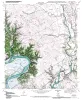
Geologic map of the Lakeside Village quadrangle, Texas | 2010 | Collins, E.W. | Open-File Map | Bureau of Economic Geology | |
|
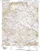
Geologic map of the Blum quadrangle, Texas | 2009 | Collins, E.W. | Open-File Map | Bureau of Economic Geology | |
|
Geologic map of the Morgan quadrangle, Texas | 2009 | Collins, E.W. | Open-File Map | Bureau of Economic Geology | |
|
Hydrogeologic significance of depositional systems and facies in Lower Cretaceous sandstones, north-central Texas | 1976 | The Lower Cretaceous Hosston and Hensel Sandstones are important sources of ground water in North-Central Texas. |
Hall, W.D. | Geological Circular | Bureau of Economic Geology |
|
The Edwards reef complex and associated sedimentation in central Texas | 1973 | The Fredericksburg Group is one of three groups of rocks which comprise the outcropping Lower Cretaceous sediments in north central Texas. Four formations form this group; from the base upward these are the Paluxy, Walnut, Comanche Peak and Edwards (fig. 1). |
Nelson, H.F. | Guidebook | Bureau of Economic Geology |

|
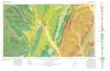
Geologic Atlas of Texas, Dallas sheet (revised 1987) | 1972 | Geologic map that depicts surface geology of Tarrant, Dallas, Kaufman, Ellis, Johnson, Somervell, and Rockwall Counties and parts of Parker, Hood, Erath, Bosque, Hill, Navarro, Henderson, Van Zandt, and Hunt Counties, Texas. |
Barnes, V.E., Shell Oil Co., Humble Oil and Refining Co., Dallas Geological Society, Fort Worth Geological Society, McGowen, J.H., Proctor, C.V., Jr., Haenggi, W.T. | Geologic Atlas of Texas | Bureau of Economic Geology |
|
Geologic Atlas of Texas, Waco sheet | 1970 | Geologic maps that depicts the surface geology of McLennan, Limestone, and Falls Counties and parts of Bosque, Hill, Navarro, Freestone, Leon, Madison, Robertson, Milam, Bell, Lampasas, Coryell, and Hamilton Counties, Texas. |
Barnes, V.E., Humble Oil and Refining Co., Shell Oil Co., Mobil Oil Co., Proctor, C.V., Jr., McGowen, J.H., Haenggi, W.T., Hayward, O.T. | Geologic Atlas of Texas | Bureau of Economic Geology |

|
Lower Cretaceous sands of Texas: stratigraphy and resources | 1967 | Lower Cretaceous sands have long been important aquifers in Central, North-Central, and North Texas. In recent years these sands also have been sources of high-silica industrial or specialty-purpose sand. |
Fisher, W.L., Rodda, P.U. | Report of Investigations | Bureau of Economic Geology |