Publications in Aransas
| Title | Publication Year Sort ascending | Abstract | Author | Series | Publisher | |
|---|---|---|---|---|---|---|
|
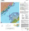
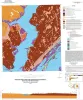
Geologic map of the Mesquite Bay area, Texas Gulf Coast | 2025 | Paine, J.G., Caudle, T.L., Grunau, B.A., Morris, J.N. | Open-File Map | Bureau of Economic Geology | |
|
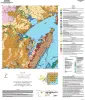
Geologic map of the Taft area, Texas Gulf Coast | 2025 | Paine, J.G., Morris, J.N., Grunau, B.A. | Open-File Map | Bureau of Economic Geology | |
|
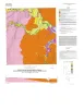
Geologic map of the Copano Bay area, Texas Gulf Coast | 2025 | Paine, J.G., Collins, E.W., Costard, L., Grunau, B.A., Morris, J.N., Caudle, T.L. | Open-File Map | Bureau of Economic Geology | |
|
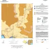
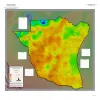
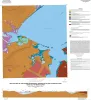
Geothermal Resources, South Texas | 2024 | A series of two 1:500,000 scale maps showing the Geothermal resources of South Texas. |
Andrews, J.R. | Open-File Map | Bureau of Economic Geology |
|
Geologic map of the Saint Charles Bay quadrangle, Texas Gulf of Mexico coast | 2016 | Paine, J.G., Collins, E.W. | Open-File Map | Bureau of Economic Geology | |
|
Geologic map of the Rincon Bend quadrangle, Aransas River and Copano Bay area, Texas Gulf of Mexico coast | 2015 | Paine, J.G., Collins, E.W., Costard, L. | Open-File Map | Bureau of Economic Geology | |
|
Geologic map of the Bayside quadrangle: Aransas Delta and Copano Bay Area, Texas Gulf of Mexico Coast | 2014 | Paine, J.G., Collins, E.W. | Open-File Map | Bureau of Economic Geology | |
|
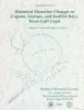
Historical shoreline changes in Copano, Aransas, and Redfish Bays, Texas Gulf coast | 1993 | Shorelines bordering the bays of Texas are generally not as dynamic as those along the Gulf of Mexico. Nevertheless, the predominantly erosional movement of these bay shorelines translates to large losses of wetlands, arable uplands, and recreational and residential property. |
Paine, J.G., Morton, R.A. | Geological Circular | Bureau of Economic Geology |
|
Core and Log Analyses of Depositional Systems and Reservoir Properties ... in Frio, Vicksburg, and Wilcox Sandstones | 1992 | The Gas Research Institute, U.S. Department of Energy, and the State of Texas cooperated in joint-venture research to evaluate the infield reserve growth potential of mature gas fields containing conventional reservoirs. |
Levey, R.A., Grigsby, J.D. | Geological Circular | Bureau of Economic Geology |
|
Submerged lands of Texas, Port Lavaca area: sediments, geochemistry, benthic macroinvertebrates, and associated wetlands | 1989 | The State-owned submerged lands of Texas encompass almost 6,000 mi2 (15,540 km2). They lie below waters of the bay-estuary-lagoon system and the Gulf of Mexico and extend 10.3 mi (16.6 km) seaward from the Gulf shoreline (fig. 1). |
White, W.A., Calnan, T.R., Morton, R.A., Kimble, R.S., Littleton, T.G., McGowen, J.H., Nance, H.S. | Submerged Lands of Texas | Bureau of Economic Geology |