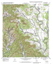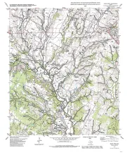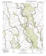
We examined the relationship between three data types--geologic maps, measurements of pavement deflection under load, and seismic refraction data-- from diverse geologic settings in Texas to determine (1) whether geologic maps and seismic refraction data might be used to interpret deflections and assess pavement condition and (2) whether deflections and refraction data acquired on pavement might have geologic applications. Engineers assess pavement condition by applying a known load to a road and measuring vertical pavement deflection using the Falling-Weight Deflectometer (FWD).
The geometry of Permian bedded salt in the Midland Basin is a product of the interaction between depositional facies and postdepositional modification by salt dissolution. Interpretation of high-frequency cycle patterns in cross section and map view inferred from wireline logs documents the salt geometry. Geologically based interpretation of depositional and dissolution processes provides a powerful tool for mapping the geometry of salt to assess the suitability of sites for development of solution-mined storage caverns.