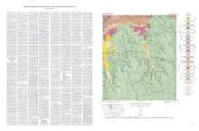
New information concerning the ancestry of the later Tertiary horses, Calippus, Protohippus (in the original sense), Hipparion, Neohipparion, and Nannippus, has been obtained from a restudy of the various mammalian farmas of the Coastal Plain in Texas, based in the main on the extensive collections of the Bureau of Economic Geology, The University of Texas. The age, stratigraphic correlation, and composition of these faunas have been reevaluated, and the results provide new evidence that has important bearing on Miocene and Pliocene intercontinental correlations of mammalian faunas.
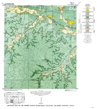

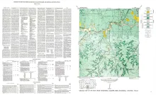
The Squaw Creek quadrangle is partly within the Llano region and partly within the Edwards Plateau province. The Edwards Plateau is continuous along the southern border of the quadrangle, but erosion has dissected it until long fingers extend northward, the most important being between Mormon and Squaw Creeks and east of Squaw Creek. The geology of the Squaw Creek quadrangle is shown on a planimetric map, and the only topographic map available is the reconnaissance 30-minute Kerrville quadrangle.