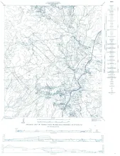
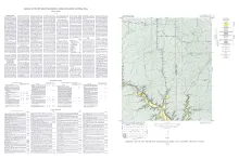
Wendel quadrangle is entirely within the Edwards Plateau province and is situated southwest of the Llano region.
The geology of the Wendel quadrangle is shown on a planimetric map, and the only topographic map available is the reconnaissance 30-minute Kerrville quadrangle. Elevations ranging between 2,041 and 2,284 feet were determined during traversing for control, but neither the highest nor the lowest elevation was reached. However, it is estimated that the relief within the quadrangle is about 270 feet, ranging between 2,020 and 2,290 feet.
Sixty-eight species of trilobites, 10 species of inarticulate brachiopods, two species of articulate brachiopods, one ostracode and fragments of sponges, pelmatozoan echinoderms and unidentifiable organisms constitute the faunas of the Riley formation. The fossils were collected from eight measured sections around the periphery of the outcrop area in Mason, Gillespie, Blanco, Burnet, Llano and SanSaba counties, Texas. All of the fossils are described and illustrated by stereophotographs.
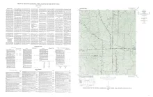
Harper quadrangle is in the Edwards Plateau province south of the Llano region. The plateau surface within the quadrangle is dissected by the Pedernales River and its tributaries in the southern part, and by Threadgill and Edwards Creeks in the northern part.
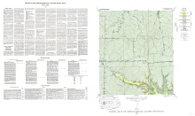
Dry Branch quadrangle is in the Edwards Plateau province southwest of the Llano region. It is near the margin of the plateau, and Johnson Creek and some of its tributaries, such as Dry Branch, Falls Branch, Fessington Branch, and Welch Branch, have cut into the plateau in the southern part of the quadrangle.