
The eastern margin of the High Plains in central western Texas affords particularly good opportunity for study of late Cenozoic geology. The topography of the area is dominated by the southernmost segment of the late Tertiary mantle of fluvial sediments, isolated from the central and northern High Plains by the valley of the Canadian River. The eastern escarpment presents many exposures and the canyons that extend into the plains contain, in addition, a nearly complete sequence of Pleistocene terraces and deposits.
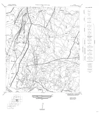
Fourteen black-and-white geologic maps prepared in 1957 and 1959 and obtained from the Department of Geological Sciences, University of Texas, and sold by the Bureau of Economic Geology. Geology compiled by F. L. Whitney; drafted by S. Espey, W. M. Strong, or W. L. Brooks; edited by K. P. Young.
Fourteen maps are included:
MM0016-A-Austin, NE (Travis and Williamson Counties)
MM0016-B-Austin, SW (Hays and Travis Counties)
MM0016-C-Bastrop (Travis County section)
MM0016-D-Blanco, SE (Hays County)
Pleistocene-age fossil horses of Texas belong to at least three faunal assemblages. The oldest contains Hippotigris (= Plesippus) which disappeared before Yarmouthian time. The second contains Equus scotti and Onager semiplicatus (= Equus (Asinus) calobatus) which disappeared before Sangamon time. Both these groups are found on the High Plains but not on the Coastal Plain or along the central Texas rivers, where a later fauna, probably of Sangamon age, is found which contains remains of Equus, Asinus, and Onager but no Hippotigris.
This paper brings part of the classification of upper Albian ammonites up to date and up to modern standards for some of the Texas species. Twelve new species are described (Drakeoceras georgetownense, D. drakei, D. arringtoni, D.kummeli, D. gabrielense, D. dellense, D. lasswitzi, Durnovarites adkinsi, Deiradoceras amsburyi, Pervinquieria whitneyi, P. smedalae, Prohysteroceras, P. atchisoni) and two previously described species are redescribed.
The lead and zinc deposits in the Upper Cambrian rocks of central Texas are reviewed in the light of new detailed information. Included are analytical data for all deposits, detailed stratigraphic sections of the Cambrian rocks, and maps at a scale of 4 inches to the mile. Igneous rocks of Carboniferous or younger age in the area are recognized for the first time.