
Virgil and lower Wolfcamp rocks on the Eastern Shelf in North-central Texas are composed of several intergradational depositional systems comprising 1,200 to 1,500 feet of off-lapping, predominantly terrigenous sediments.
The Eddleman Coal (Thrifty Formation, Cisco Group) in Young County, Texas, yielded a spore and pollen flora which was classified into 37 genera and 65 species. Ten species are regarded as new and are assigned to existing genera. A single new species is described and placed within a new genus. New taxa are named and described in accordance with the rules of the International Code of Botanical Nomenclature (1961).
Upper Pensylvanian and lower Permian rocks of the Eastern Shelf in North-central Texas are composed of 10 to 15 repetitive sequences including open shelf, deltaic, fluvial, and interdeltaic depositional systems. Sediments derived from the Ouachita Mountains and associated piedmont were transported westward across a narrow coastal plain. Fluvial and deltaic sandstone fac1es define a southwest paleoslopc of about 5 feet per mile. Sandstone facies are delta front sheets, distributary mouth bars, distributary and fluvial channels, and destructional bars.
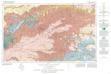
Geologic map that depicts the surface geology of Carson, Gray, and Wheeler Counties and parts of Moore, Hutchinson, Roberts, Hemphill, Potter, Randall, Armstrong, Donley, and Collingsworth Counties.