Papers in this volume were presented at the Fourth Forum on Geology of Industrial Minerals sponsored by the Bureau of Economic Geology, The University of Texas at Austin, on March 14 and 15, 1968. The program and meetings were organized and directed by co-chairmen W. L. Fisher and P. U. Rodda, Bureau of Economic Geology. Papers in this volume are arranged in the order of presentation at the meetings; contributions have been edited only as necessary to present a standard format. Mr. James Macon, Cartographer, and Mrs. Elizabeth T.
![Texas Mining Laws Pertaining to State Public Lands [as of 1968]](/files/styles/medium/public/publication_covers/MM0033.jpg.webp?itok=rYQbRj6O)
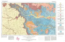
Geologic map that depicts surface geology of Swisher, Briscoe, Hall, and Childress Counties and parts of Randall, Armstrong, Donley, Collingsworth, Hale, Floyd, Motley, and Cottle Counties. This map was published as a memorial to William Fletcher Cummins, who pioneered in mapping West Texas geology and specialized in the study of Permian rocks of West Texas and New Mexico. These rocks are depicted in the eastern two-thirds of the Plainview Sheet.
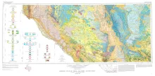
Geologic map that depicts the surface geology of El Paso County and parts of Hudspeth. Jeff Davis, and Culberson Counties, Texas. The 12-page booklet indicates geologic formations, abbreviations, and ages. Published in honor of E. Russell Lloyd, distinguished Texas independent petroleum geologist, who prior to his death in 1955 edited much of the geological writing concerning the Permian Basin area. His geologic interpretation of the Capitan Limestone as a reef furnished the basis for interpretation of the associated formations and their oil-bearing possibilities.