|
GCAGS Transactions Volume 47 (1997) New Orleans |
|
1997 |
Gulf Coast Association of Geological Societies |
|
Atlas of northern Gulf of Mexico gas and oil reservoirs: Volume 1. Miocene and older reservoirs |
Seni, S.J., Hentz, T.F., Kaiser, W.R. |
1997 |
Atlases of Major Oil and Gas Reservoirs |
|
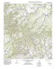
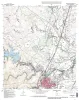
Geologic map of the Del Rio NW Quadrangle, Texas |
Collins, E.W. |
1997 |
Open-File Map |
|
Environment and Restoration in the Central Texas Hill Country, A Geologic Excursion to Selah, Bamburger Ranch, Blanco County, Texas |
Woodruff, C.M., Jr. |
1997 |
Austin Geological Society |
|
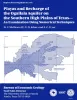
Annual Report of the Bureau of Economic Geology 1997 |
University of Texas at Austin, Bureau of Economic Geology |
1997 |
Annual Reports |
|
Atlas of northern Gulf of Mexico gas and oil reservoirs: Volume 2. Pliocene and Pleistocene reservoirs |
Hentz, T.F., Seni, S.J., Wermund, E.G. |
1997 |
Atlases of Major Oil and Gas Reservoirs |
|
Geologic map of the Del Rio SW Quadrangle, Texas |
Collins, E.W. |
1997 |
Open-File Map |
|
Oil and Gas on Texas State Lands: An Assessment of the Resource and Characterization of Type Reservoirs |
Holtz, M.H., Garrett, C.M., Jr. |
1997 |
Report of Investigations |
|
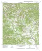
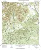
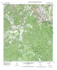
Geologic map of the Tarpley Pass Quadrangle, Texas |
Collins, E.W. |
1997 |
Open-File Map |
|
Salt Thickness and Other Geologic Factors Important to Salt Caverns in the Midland Basin, Texas - Poster |
Hovorka, S.D. |
1997 |
Posters |
|
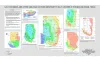
Playas and recharge of the Ogallala aquifer on the southern High Plains of Texas -- an examination using numerical techniques |
Mullican, W.F., Johns, N.D., Fryar, A.E. |
1997 |
Report of Investigations |
|
Geologic map of the Tarpley Quadrangle, Texas |
Collins, E.W. |
1997 |
Open-File Map |
|
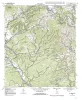
Geologic map of the Georgetown quadrangle, Texas |
Collins, E.W. |
1997 |
Open-File Map |
|
Spatial variability in unsaturated flow beneath playa and adjacent interplaya settings and implications for contaminant transport, southern High Plains, Texas |
Scanlon, B.R., Goldsmith, R.S., Mullican, W.F. |
1997 |
Report of Investigations |
|
Geologic map of the Texas Mountain quadrangle, Texas |
Collins, E.W. |
1997 |
Open-File Map |
|
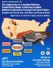
The Application of a Coalbed Methane Producibility Model in Defining Coalbed Methane Exploration Fairways and Sweet Spots: Examples from the San Juan, Sand Wash, and Piceance Basins |
Tyler, Roger, Scott, A.R., Kaiser, W.R., McMurry, R.G. |
1997 |
Report of Investigations |
|
Geologic map of the Timber Creek Quadrangle, Texas |
Collins, E.W. |
1997 |
Open-File Map |
|
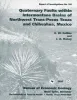
Quaternary faults within intermontane basins of northwest Trans-Pecos Texas and Chihuahua, Mexico |
Collins, E.W., Raney, J.A. |
1997 |
Report of Investigations |
|
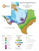
Tectonic Map of Texas |
University of Texas at Austin, Bureau of Economic Geology |
1997 |
Thematic Maps |
|
Geologic map of the Twin Hollow Quadrangle, Texas |
Collins, E.W. |
1997 |
Open-File Map |