|
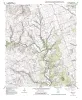
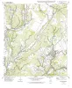
Geologic map of the Nameless Quadrangle, Texas |
Collins, E.W. |
1999 |
Open-File Map |
|
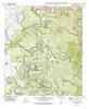
Geologic map of the Flat Rock Crossing Quadrangle, Texas |
Collins, E.W. |
1999 |
Open-File Map |
|
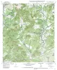
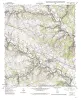
Geologic map of the Luling quadrangle, Texas |
Collins, E.W. |
1999 |
Open-File Map |
|
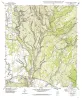
Geologic map of the Prairie Valley School quadrangle, Texas |
Collins, E.W. |
1999 |
Open-File Map |
|
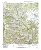
Geologic map of the Mahomet Quadrangle, Texas |
Collins, E.W. |
1999 |
Open-File Map |
|
Geologic map of the Flat Rock Creek SW quadrangle, Texas |
Collins, E.W. |
1999 |
Open-File Map |
|
Geologic map of the Liberty Hill Quadrangle, Texas |
Collins, E.W. |
1999 |
Open-File Map |
|
Geologic map of the Mud Creek North quadrangle, Texas |
Collins, E.W. |
1999 |
Open-File Map |
|
Geologic map of the Mud Creek South quadrangle, Texas |
Collins, E.W. |
1999 |
Open-File Map |
|
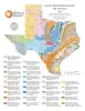
Land-Resource Map of Texas |
Wermund, E.G. |
1999 |
Thematic Maps |
|
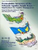
Permeability structure of the Edwards aquifer, south Texas -- implications for aquifer management |
Hovorka, S.D., Mace, R.E., Collins, E.W. |
1998 |
Report of Investigations |
|
Bibliography of Gulf Coast Geology (V. 7) |
|
1998 |
Gulf Coast Association of Geological Societies |
|
Geology of Big Bend Ranch State Park, Texas |
Henry, C.D. |
1998 |
Guidebook |
|
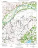
Geologic map of the Sabinal NE quadrangle, Texas |
Collins, E.W. |
1998 |
Open-File Map |
|
Architecture and Permeability Structure of a Composite Valley Fill in the Cretaceous Fall River Formation of South Dakota |
Willis, B.J. |
1998 |
Report of Investigations |
|
Geologic Controls on Reservoir Architecture and Hydrocarbon Distribution in Miocene Shoreface Fluvial and Deltaic Deposits in the Mioceno Norte Area, Lake Maracaibo, Venezuela |
Ambrose, W.A., Mendez, M., Akhter, M.S. |
1998 |
Report of Investigations |
|
3-D Seismic Stratal-Surface Concepts Applied to the Interpretation of a Fluvial Channel System... |
Hardage, B.A., Remington, R.L. |
1998 |
Geological Circular |
|
Tertiary volcanism of the Boficillos Mountains and Big Bend Ranch State Park, Texas: revised stratigraphy and 40Ar/39Ar geochronology |
Henry, C.D., Davis, L.L., Kunk, M.J., McIntosh, W.C. |
1998 |
Report of Investigations |
|
Facies and diagenesis of the Austin Chalk and controls on fracture intensity -- a case study from north-central Texas |
Hovorka, S.D. |
1998 |
Geological Circular |
|
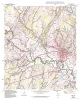
Geologic map of the Leander Quadrangle, Texas |
Collins, E.W. |
1998 |
Open-File Map |